Home
Weather New York
WeatherRadar
RainRadar
TemperatureRadar
WindRadar
LightningRadar
Weather News
Editor's Pick
Discover the app
Weather widget
Contact us
Apps
Career
    Home / Weather News /

    Breakfast Brief: Slow warm up, another clipper

10:00 AM
January 27, 2025

Breakfast brief
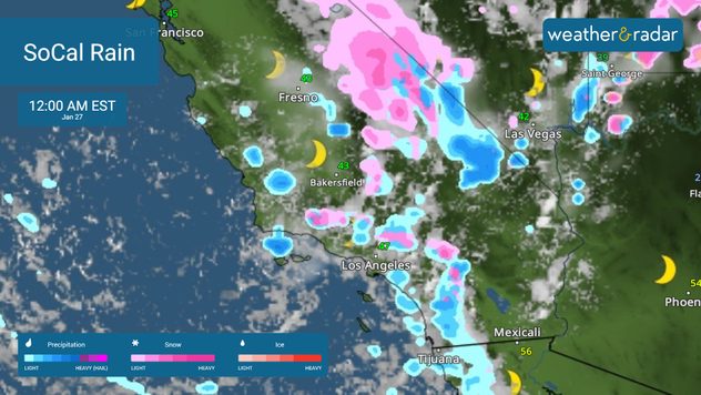
Much-needed rain for SoCal

Much-needed rain swirls around a low in southern California, reducing fire danger. Scattered showers impact much of the South. The Breakfast Brief is published daily, Monday through Friday, at 5:00 a.m. Eastern time.

The WeatherRadar shows much-needed rain in southern California. A slow-moving low will bring moisture to the region that has been battling extreme wildfires since the beginning of the year. The WindRadar also shows more favorable westerly winds moving across the area. Westerly winds bring in more moisture, increasing humidity levels and reducing the fire danger.

Showers will spread along a front draped across the South today. Wet weather is forecast from San Antonio, Texas, to Savannah, Georgia. With gloomy conditions in the forecast, you'll want to grab the rain gear.

Sunny conditions will prevail across much of the rest of the country, except for the snowbelt regions downwind of the Great Lakes, where some lake-effect snow showers are expected.

News we're covering today:

  • Fire relief in SoCal
  • Lake-effect snow for the Great Lakes
  • Wet weather in the South

Did you miss these:

Specialized notifications just for youread more
Storm Éowyn slams Irelandread more

App news & updates:

Poor air quality can be an issue at any time of year. If you are in a sensitive group, our air quality tool has all the information you need to make decisions about your day.

Mary Mays
More on the topic
Europe: Warmest June on record. Warm waters too. . . Friday, July 10, 2026
The record-breaking heatwave in June has made climate history in Western Europe.
Friday, July 10, 2026

Warm waters too

Europe: Warmest June on record
Super Typhoon Bavi threatens Taiwan. 155 mph winds. . Weather Videos. Wednesday, July 8, 2026
The image shows an intense tropical cyclone over the western Pacific, east of Taiwan and the Philippines. The centre of the system is depicted as a light purple and white vortex with a clearly visible eye, surrounded by a ring of red and orange areas indicating the strongest wind speeds. A white arrow marks the typhoon’s predicted track towards the north-west, in the direction of Taiwan. To the west of the storm lie the Philippines, with the cities of Manila and Cebu; to the north of these lies Taiwan, with Taipei. Further west, the Chinese coast, including Hong Kong, and parts of Vietnam can be seen. The coloured wind map shows predominantly green areas outside the storm’s core, indicating significantly weaker winds. White streamlines illustrate the typhoon’s anti-clockwise circulation in the Northern Hemisphere. The highest wind speeds are concentrated around the eye of the cyclone.
Weather VideosWednesday, July 8, 2026

155 mph winds

Super Typhoon Bavi threatens Taiwan
Rip currents & safety tips. As more head to the coast. . . Sunday, July 5, 2026
rip current
Sunday, July 5, 2026

As more head to the coast

Rip currents & safety tips
All weather news
This might also interest you
Wildfire smoke travels 1K+ miles. Canada to Mid-Atlantic. . . Tuesday, July 14, 2026
Tuesday, July 14, 2026

Canada to Mid-Atlantic

Wildfire smoke travels 1K+ miles
Desert Southwest heat for the Dakotas. 1,000-mile difference. . . Monday, July 13, 2026
Monday, July 13, 2026

1,000-mile difference

Desert Southwest heat for the Dakotas
Turning hot this weekend. Brutal temps across West. . . Friday, July 10, 2026
Saturday & Sunday's highs
Friday, July 10, 2026

Brutal temps across West

Turning hot this weekend
All articles
Weather & Radar

Weather & Radar is also available on

Google Play StoreApp Store

Company

Contact us Privacy policy Legal info Accessibility statement

Services

Uploader

Socials

instagramfacebookthreadslinkList