Home
Weather New York
WeatherRadar
RainRadar
TemperatureRadar
WindRadar
LightningRadar
Weather News
Editor's Pick
Discover the app
Weather widget
Contact us
Apps
Career
    Home / Weather News /

    Breakfast Brief: Soaked south Florida, summer's incoming
09:00 AM
June 11, 2024

Breakfast brief
Soaked south Florida, summer's incoming

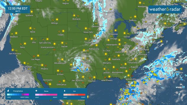
weatherradar june 11

A very wet week ahead in South Florida, with high chances for heavy rainfall each day and potential flash flooding concerns. Meanwhile, today marks the first day of a warming trend across the Great Lakes and Northeast, with summer temperatures on the way.

Did you know?

On this day, in 1998, a severe thunderstorm produced baseball-sized hail in Oklahoma City, Oklahoma, causing widespread damage to vehicles, roofs, and windows, and leading to millions of dollars in damages

Today's weather outlook

The WeatherRadar Monday morning shows moderate to heavy rain starting to expand across South Florida. This system is associated with a pocket of tropical moisture that will bring widespread rain to the central and southern portions of the state. Currently, South Florida looks to take the brunt of the rain, particularly southwest Florida where localized amounts up to 15 inches are possible.

To the north, unseasonably cool air lingers this morning. However, if you're not a fan of the heat, enjoy it, because today is the beginning of a marked warming trend that will bring back summer temperatures by the weekend. Most areas will reach the 80s by Thursday before another storm-bearing cold front arrives from the west. This system will introduce another shot of cool air, but won't be as potent or long-lasting as last week's.

Across the West, unseasonably warm temperatures continue, but a break in the weather pattern will bring a welcomed change. Starting from the northwest, a Pacific low-pressure system will gradually spread rain chances and cool air across the region starting next week Thursday. See the temperatures radar to track the cooler weather.

Tropical update

As mentioned above, a pocket of deep tropical moisture will bring near-record-breaking moisture across Florida, resulting in heavy rain and isolated flash flooding across the state. Once this system moves to the Atlantic there is a low chance it could develop into a tropical system, read more here.

The news we're covering today:

  • Tropical moisture brings Florida downpours
  • How big does hail have to be to damage cars?

Did you miss these?

Plane struck by hail mid-flightread more
New Texas hail record - 7.5 inchesread also
Preparing for 2024 hurricane seasonread more

App news & updates:

Whether you're working outdoors or attending an event, you can rely on the LightningRadar to keep you informed about the weather in real-time, anywhere across the globe. The latest upgrade to the LightningRadar now extends the visibility of lightning activity to the past 90 minutes, significantly expanding from the previous 15-minute window.

Federico Di Catarina
More on the topic
Super Typhoon Near the Philippines. Gusts up to 155. . . Tuesday, June 23, 2026
Tuesday, June 23, 2026

Gusts up to 155

Super Typhoon Near the Philippines
How does fog form?. Multiple ways. . . Saturday, July 11, 2026
Saturday, July 11, 2026

Multiple ways

How does fog form?
Super Typhoon Bavi threatens Taiwan. 155 mph winds. . Weather Videos. Wednesday, July 8, 2026
The image shows an intense tropical cyclone over the western Pacific, east of Taiwan and the Philippines. The centre of the system is depicted as a light purple and white vortex with a clearly visible eye, surrounded by a ring of red and orange areas indicating the strongest wind speeds. A white arrow marks the typhoon’s predicted track towards the north-west, in the direction of Taiwan. To the west of the storm lie the Philippines, with the cities of Manila and Cebu; to the north of these lies Taiwan, with Taipei. Further west, the Chinese coast, including Hong Kong, and parts of Vietnam can be seen. The coloured wind map shows predominantly green areas outside the storm’s core, indicating significantly weaker winds. White streamlines illustrate the typhoon’s anti-clockwise circulation in the Northern Hemisphere. The highest wind speeds are concentrated around the eye of the cyclone.
Weather VideosWednesday, July 8, 2026

155 mph winds

Super Typhoon Bavi threatens Taiwan
All weather news
This might also interest you
Moisture surge fuels strong storms. Northeast deluge. . . Friday, August 7, 2026
Friday, August 7, 2026

Northeast deluge

Moisture surge fuels strong storms
The meeting of the wet masses. A Florida story. . . Wednesday, August 5, 2026
Two air masses conerge to produce storms & heavy downpours across the Florida Peninsula today.
Wednesday, August 5, 2026

A Florida story

The meeting of the wet masses
Big 50-degree jump. Northwest heat extremes. . . Thursday, August 6, 2026
Big temperature jumps
Thursday, August 6, 2026

Northwest heat extremes

Big 50-degree jump
All articles
Weather & Radar

Weather & Radar is also available on

Google Play StoreApp Store

Company

Contact us Privacy policy Legal info Accessibility statement

Services

Uploader

Socials

instagramfacebookthreadslinkList