Home
Weather New York
WeatherRadar
RainRadar
TemperatureRadar
WindRadar
LightningRadar
Weather News
Editor's Pick
Discover the app
Weather widget
Contact us
Apps
Career
    Home / Weather News /

    Breakfast Brief: Stormy Southeast, Record heat West

09:00 AM
June 2, 2025

Daily Briefing
Pattern change brings relief to the West
Today is the second day of the Atlantic Hurricane Season, and from here until November 30, the Daily Briefing will include a Tropical Update. A pattern shift will bring cooler weather to the West. The Daily Briefing is published Monday through Friday at 5:00 a.m. Eastern Time.

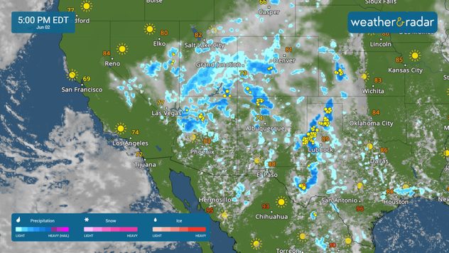
After record heat over the weekend, a pattern shift will bring rain and cooler temperatures to the West to start the work week. The WeatherRadar shows showers and storms across the Southwest, southern Plains and Rockies today. Cities like Phoenix and Salt Lake City are expected to experience below-average temperatures due to the rain.

A cold front moving across the northern Plains could spark off a few strong afternoon and evening storms stretching from Valentine, Neb., to Fargo, N.D. Make sure your Weather & Radar app alerts are on.

The TemperatureRadar shows a flip in the pattern from the weekend. After record heat in parts of the West, cooler temperatures will be in place from Montana to the Desert Southwest. However, heat will build across the Upper Midwest, with Minneapolis nearing 90 this afternoon.

Temperatures across the Southeast will be near-average in the 70s and 80s today, with comfortable highs expected in the Northeast. Both Washington, D.C., and New York will see highs near 70.

Tropical Update

A non-tropical area of low pressure is forecast to form near or offshore of the Southeast during the next couple of days. If the system remains offshore, the low could gradually develop some subtropical or tropical characteristics later this week while moving northeastward at 10 to 15 mph.

News we're covering today

  • Pattern flip
  • Wet weather in the Southwest
2025 Hurricane season forecastread more

App news

Hurricane season is underway! Did you know the Weather & Radar app offers Hurricane Alerts? Learn about them here.

Mary Mays
More on the topic
Meteorological vs astronomical autumn. Season start date. . . Tuesday, September 1, 2026
Tuesday, September 1, 2026

Season start date

Meteorological vs astronomical autumn
Hurricane parade in the Pacific. Karina is very strong. . Weather Videos. Tuesday, September 1, 2026
WindRadar for Friday, showing the three hurricanes – Lowell, Karina and Maria – over the Pacific.
Weather VideosTuesday, September 1, 2026

Karina is very strong

Hurricane parade in the Pacific
Record ocean heat halting hurricanes. Strong El Niño influence. . . Sunday, September 13, 2026
A weather map shows a calm Atlantic Ocean with no hurricanes, alongside a picture of the sea.
Sunday, September 13, 2026

Strong El Niño influence

Record ocean heat halting hurricanes
All weather news
This might also interest you
More than 20 inches of rain from Edouard. Possible drought help?. . . Thursday, September 3, 2026
Thursday, September 3, 2026

Possible drought help?

More than 20 inches of rain from Edouard
1,000+ miles of storms. 3 Time zones of action. . . Wednesday, September 9, 2026
Wednesday, September 9, 2026

3 Time zones of action

1,000+ miles of storms
What is it, and why is it important?. North American Monsoon. . . Sunday, September 6, 2026
Desert thunderstorm
Sunday, September 6, 2026

North American Monsoon

What is it, and why is it important?
All articles
Weather & Radar

Weather & Radar is also available on

Google Play StoreApp Store

Company

Contact us Privacy policy Legal info Accessibility statement

Services

Uploader

Socials

instagramfacebookthreadslinkList