Home
Weather New York
WeatherRadar
RainRadar
TemperatureRadar
WindRadar
LightningRadar
Weather News
Editor's Pick
Discover the app
Weather widget
Contact us
Apps
Career
    Home / Weather News /

    Breakfast brief: Wet in the Northeast, hot in Texas

08:00 AM
May 22, 2025

Breakfast Brief
Wet in the Northeast, hot in Texas

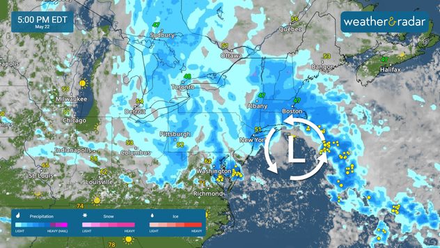
Low pressure will send showers and storms across the Northeast today. Warmer than average temperatures build across the southern tier, with more record highs possible in Texas. The Breakfast Brief is published Monday through Friday at 5:00 a.m. Eastern Time.

The WeatherRadar shows soggy conditions for the Northeast as low pressure sends showers and storms across the region. Cities including Pittsburgh, New York, Washington, D.C., New York and Boston will need the rain gear throughout the day.

Thunder will also rumble across the Plains, Southeast, Mid-Atlantic and Florida. A few strong storms are possible in Texas and Oklahoma, including in Dallas, Wichita Falls, Texas, and Fort Sill, Okla. A couple of strong storms may also be an issue from Melbourne to Miami, Fla. Damaging winds and hail are the main threats.

Are your weather alerts switched on in the app?

A few showers will impact the Pacific Northwest today, with tranquil conditions across California and the Southwest. Heat will build across the southern tier, with cooler-than-average temperatures staying north.

The TemperatureRadar shows highs well in the 90s and even a few areas reaching the triple digits across the Southwest and into Texas. Record highs are possible in Austin and San Antonio. Sweltering heat will also impact South Florida, with Miami topping out in the 90s.

Due to rain and storms, temperatures in the Northeast will run up to 20 degrees below average. Highs in New York and Boston will only top out in the 50s today. The Midwest will also stay cooler than average, with cities like Chicago only reaching the 50s.

News we're covering today

  • Wet northeast
  • Hot across the southern tier

Things you may have missed

Violent tornado hits Kentuckyread more

App news

When severe weather is in your forecast, you can be prepared. Follow along with these tools to stay weather-aware.

Mary Mays
More on the topic
10 facts about fog. Low clouds. . . Sunday, September 27, 2026
Fog impacting the Appalachian Mountains.
Sunday, September 27, 2026

Low clouds

10 facts about fog
Hurricane parade in the Pacific. Karina is very strong. . Weather Videos. Tuesday, September 1, 2026
WindRadar for Friday, showing the three hurricanes – Lowell, Karina and Maria – over the Pacific.
Weather VideosTuesday, September 1, 2026

Karina is very strong

Hurricane parade in the Pacific
Hurricane Polo remains dangerous. Active Pacific. . . Thursday, September 24, 2026
Thursday, September 24, 2026

Active Pacific

Hurricane Polo remains dangerous
All weather news
This might also interest you
First hurricane of the Atlantic season. Isaias forms. . . Thursday, October 8, 2026
After a quiet start, the Atlantic's first hurricane has finally formed. Isaias is the latest first hurricane since the satellite era began in1966. With the Gulf Coast in sight, what impacts are expected?
Thursday, October 8, 2026

Isaias forms

First hurricane of the Atlantic season
October astro outlook. Look up!. . . Saturday, October 3, 2026
Star gazing - Astro outlook
Saturday, October 3, 2026

Look up!

October astro outlook
Rounds of rain for Florida. Not so Sunshine State. . . Monday, October 5, 2026
While October typically marks a transition to drier weather in Florida, the first full week of the month is kicking off with heavy rain. But how much rain are we talking about?
Monday, October 5, 2026

Not so Sunshine State

Rounds of rain for Florida
All articles
Weather & Radar

Weather & Radar is also available on

Google Play StoreApp Store

Company

Contact us Privacy policy Legal info Accessibility statement

Services

Uploader

Socials

instagramfacebookthreadslinkList