Home
Weather New York
WeatherRadar
RainRadar
TemperatureRadar
WindRadar
LightningRadar
Weather News
Editor's Pick
Discover the app
Weather widget
Contact us
Apps
Career
    Home / Weather News /

    Daily briefing: Autumn heads East

09:00 AM
September 4, 2025

Daily briefing
Autumn heads East

It will feel more like autumn over more of the U.S. as a cold front brings some rain to the East and Northeast. These details, along with our daily tropical outlook, are published every weekday at 5 a.m. ET.

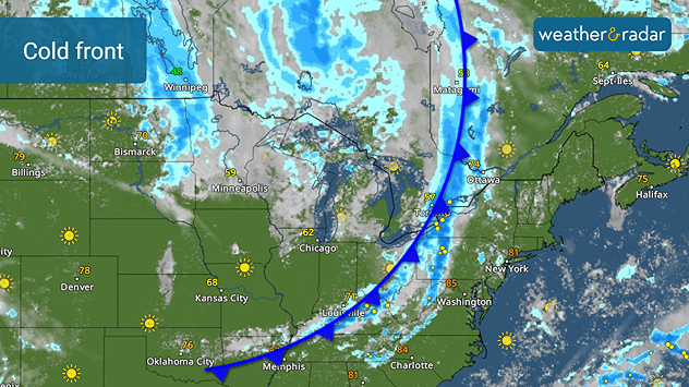
The WeatherRadar shows a slow-moving cold front moving across the Great Lakes, which will edge into the Northeast and the Mid-Atlantic today. It will touch off showers, with a few afternoon thunderstorms possible.

A slow moving cold front will bring rain to the Mid-Atlantic and Northeast.

Behind the front, it will be chilly with highs in the 60s and the 70s throughout the Midwest and Great Lakes. A few afternoon showers will be possible across the Upper Midwest and northern Great Lakes.

The Southeast, South and southern Plains will be hot with highs in the 90s with triple digits in Texas. A few late thunderstorms are likely Thursday afternoon.

Heading west, the Southwest, while a few afternoon thunderstorms build across the Rockies and Great Basin. California and the Northwest will be sunny and warm with highs in the 80s and 90s. The immediate Pacific Coast will be in the 70s.

Tropical Update

A tropical wave continues to move west over the east-central Atlantic. Additional development is likely over the next several days as it remains far from land.

App News

The Atlantic Hurricane Season peaks in September, and you will want to be ready. Learn more about how our hurricane alerts work here.

James West
More on the topic
Hawaii's second 2026 hurricane impact. Hurricane Lowell. . . Tuesday, September 8, 2026
Tuesday, September 8, 2026

Hurricane Lowell

Hawaii's second 2026 hurricane impact
Hurricane parade in the Pacific. Karina is very strong. . Weather Videos. Tuesday, September 1, 2026
WindRadar for Friday, showing the three hurricanes – Lowell, Karina and Maria – over the Pacific.
Weather VideosTuesday, September 1, 2026

Karina is very strong

Hurricane parade in the Pacific
Record ocean heat halting hurricanes. Strong El Niño influence. . . Sunday, September 13, 2026
A weather map shows a calm Atlantic Ocean with no hurricanes, alongside a picture of the sea.
Sunday, September 13, 2026

Strong El Niño influence

Record ocean heat halting hurricanes
All weather news
This might also interest you
Moisture from Simon supercharges rain. Central US. . . Wednesday, October 14, 2026
Tropical moisture from Pacific Hurricane Simon is supercharging rainfall totals across portions of the central and southern Plains. Record-high moisture levels are being observed due to this setup.
Wednesday, October 14, 2026

Central US

Moisture from Simon supercharges rain
45-degree temperature spread. Summer, fall on one map. . . Monday, October 12, 2026
Monday, October 12, 2026

Summer, fall on one map

45-degree temperature spread
Tropical downpours for the West. Rachel's remnants. . . Sunday, October 11, 2026
Not just one, but two post-tropical systems are bringing a deluge to the U.S. this weekend. Moisture from the remnants of Tropical Storm Rachel will bring downpours to parts of the West into early next week.
Sunday, October 11, 2026

Rachel's remnants

Tropical downpours for the West
All articles
Weather & Radar

Weather & Radar is also available on

Google Play StoreApp Store

Company

Contact us Privacy policy Legal info Accessibility statement

Services

Uploader

Socials

instagramfacebookthreadslinkList