Home
Weather New York
WeatherRadar
RainRadar
TemperatureRadar
WindRadar
LightningRadar
Weather News
Editor's Pick
Discover the app
Weather widget
Contact us
Apps
Career
    Home / Weather News /

    Daily briefing: Rain, snow & clouds for the North

10:00 AM
January 13, 2026

Daily briefing
Rain, snow & clouds for the North

A low-pressure trough will dip into the northern tier today, bringing scattered rain, snow and cloudy weather from the High Plains to Kansas City and eastward into the Northeast. Texas and Florida will have showers, too. The daily briefing is published every weekday at 5 a.m. ET.

The trough will have snow dipping into the northern Plains, Upper Midwest and interior Northeast, while the mix of clouds and rain showers will reach as far south as the central Plains and the Ohio Valley.

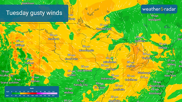
Gusty winds will accompany the trough, with the highest gusts forecast to reach 40 mph for some. Those with holiday decorations still up from the High Plains to the Mid-Atlantic will need to make sure these are secured.

Gusty winds for Tuesday.
The WindRadar shows gusty winds across the northern tier on Tuesday.

A low-pressure system will scooch across Texas, triggering scattered shower activity before reaching the lower Mississippi Valley later this afternoon and evening.

A stalled front will have many using umbrellas out in central and southern Florida.

High temperatures will be in the 50s and 60s for much of the South and central U.S., the West Coast and even as far north as the Montana High Plains. Colder 30s and 40s will spread throughout the Mountain West as well as into the northern tier, the Great Lakes and well into the Northeast.

App news

New year, best weather app! Share your love for Weather & Radar with a friend or loved one.

Becca Parker
More on the topic
Super Typhoon Bavi threatens Taiwan. 155 mph winds. . Weather Videos. Wednesday, July 8, 2026
The image shows an intense tropical cyclone over the western Pacific, east of Taiwan and the Philippines. The centre of the system is depicted as a light purple and white vortex with a clearly visible eye, surrounded by a ring of red and orange areas indicating the strongest wind speeds. A white arrow marks the typhoon’s predicted track towards the north-west, in the direction of Taiwan. To the west of the storm lie the Philippines, with the cities of Manila and Cebu; to the north of these lies Taiwan, with Taipei. Further west, the Chinese coast, including Hong Kong, and parts of Vietnam can be seen. The coloured wind map shows predominantly green areas outside the storm’s core, indicating significantly weaker winds. White streamlines illustrate the typhoon’s anti-clockwise circulation in the Northern Hemisphere. The highest wind speeds are concentrated around the eye of the cyclone.
Weather VideosWednesday, July 8, 2026

155 mph winds

Super Typhoon Bavi threatens Taiwan
Rip currents & safety tips. As more head to the coast. . . Saturday, July 25, 2026
rip current
Saturday, July 25, 2026

As more head to the coast

Rip currents & safety tips
The best views of Wednesday's eclipse. Europe's sky show. . . Thursday, August 13, 2026
Solar eclipse: The sun obscured between wind turbines in Sardinia
Thursday, August 13, 2026

Europe's sky show

The best views of Wednesday's eclipse
All weather news
This might also interest you
100 days of at least 100°F. Phoenix. . . Wednesday, August 26, 2026
Wednesday, August 26, 2026

Phoenix

100 days of at least 100°F
Tornado producer brings fall refresh. Northeast low. . . Friday, August 21, 2026
Friday, August 21, 2026

Northeast low

Tornado producer brings fall refresh
Dust Bowl period record could fall. North Texas. . . Tuesday, August 25, 2026
Tuesday, August 25, 2026

North Texas

Dust Bowl period record could fall
All articles
Weather & Radar

Weather & Radar is also available on

Google Play StoreApp Store

Company

Contact us Privacy policy Legal info Accessibility statement

Services

Uploader

Socials

instagramfacebookthreadslinkList