Home
Weather New York
WeatherRadar
RainRadar
TemperatureRadar
WindRadar
LightningRadar
Weather News
Editor's Pick
Discover the app
Weather widget
Contact us
Apps
Career
    Home / Weather News /

    Daily briefing: Rain, storms ahead of cold front

09:00 AM
July 31, 2025

Daily briefing
Rain, storms ahead of cold front

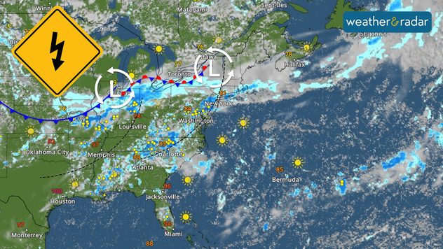
The temperatures are slowly on a downward trend as a cold front spawns from the Central Plains through the Northeast, producing plenty of showers and storms ahead of it. The Daily Briefing is published daily at 5 a.m. ET and includes a look at the tropics.

There is a cold front slowly moving east-southeast, stretching from the Central Plains through the Northeast. Just ahead of this front, there is plenty of moisture that brings unstable weather in the morning over the northern Ozarks through the southern Great Lakes. The skies will gradually clear in Chicago as the afternoon progresses; meanwhile, the weather deteriorates across the Tri-State region in the afternoon hours into the evening.

The storms across the Northeast will be more intense, with higher moisture content, and they will persist throughout the day, bringing more intense rains, probably higher rain rates, in the afternoon into the evenings. Rainfall will range between 1 and 3 inches, and some areas could receive up to 5 inches.

Over the Southeast, several troughs will bring rounds of showers and storms over Alabama, northern Georgia, and the Carolinas. The afternoon will be plagued with intense storms over the Appalachians. One to 2 inches of rainfall are expected, with some isolated spots receiving 3 inches. The highest amounts will likely be combined across northeastern South Carolina and southeastern North Carolina.

Strong quake off Russia's east coastread more

Across the Rockies, the stream of moisture from the Pacific will continue to build up and produce numerous rain showers across the Front Range that will expand to the southern Rockies. Keep in mind that the ground is well saturated across New Mexico, and flooding is possible, especially over burn scar areas.

Tropical Update

Across the tropical Atlantic, we’re not expecting any tropical storm formation for the remainder of the week.

App news

Do you understand our TemperatureRadar's colors? Read what else it offers, here.

Irene Sans
More on the topic
The only Blue Moon of the year rises. May astronomy outlook. . . Saturday, May 2, 2026
Saturday, May 2, 2026

May astronomy outlook

The only Blue Moon of the year rises
Meteorological summer is here!. Bye, spring!. . . Monday, June 1, 2026
Monday, June 1, 2026

Bye, spring!

Meteorological summer is here!
Heat wave setting records across Europe. London breaks May record. . . Tuesday, May 26, 2026
European heat wave
Tuesday, May 26, 2026

London breaks May record

Heat wave setting records across Europe
All weather news
This might also interest you
Hotter in Detroit than Miami. Heatwave begins. . . Tuesday, June 30, 2026
Tuesday, June 30, 2026

Heatwave begins

Hotter in Detroit than Miami
Slow-moving storms and heavy rain. What to look for. . . Monday, July 6, 2026
Monday, July 6, 2026

What to look for

Slow-moving storms and heavy rain
Saharan dust to reach Florida. Dry period expected. . . Tuesday, July 7, 2026
Saharan dust seen on the satllite image (right) moving westward toward Florida. Air quality impacts are expected.
Tuesday, July 7, 2026

Dry period expected

Saharan dust to reach Florida
All articles
Weather & Radar

Weather & Radar is also available on

Google Play StoreApp Store

Company

Contact us Privacy policy Legal info Accessibility statement

Services

Uploader

Socials

instagramfacebookthreadslinkList