Home
Weather New York
WeatherRadar
RainRadar
TemperatureRadar
WindRadar
LightningRadar
Weather News
Editor's Pick
Discover the app
Weather widget
Contact us
Apps
Career
    Home / Weather News /

    Daily briefing: Rainy Monday across Northeast, Midwest

09:00 AM
September 22, 2025

Daily briefing
Rainy Monday across Northeast, Midwest

Much-needed rain will kick off the work week throughout the Great Lakes, Ohio Valley and the Northeast. Storms will also be found across Florida and the Rockies too. This, and our tropical update, are available at 5 a.m. ET in our daily briefing.

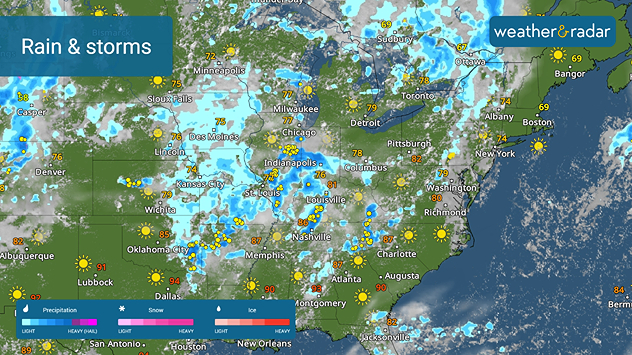
The WeatherRadar shows a slow-moving autumn storm system extending from the lower and central Mississippi Valley northeastward into the Great Lakes and the Northeast. A drought has developed across these areas, so this rain will be very beneficial. A few rumbles of thunder will also be possible across the Ohio Valley into the Appalachians.

Much-needed rain soaks the Midwest, Northeast

Scattered afternoon showers and thunderstorms will also be possible across Florida and the Rockies into the southern high Plains today. The West and central Plains will be quiet with a sun-filled sky.

Although the autumn equinox occurs at 2:19 p.m. EDT today, it will still feel like summer east of the Rockies. The TemperatureRadar shows highs in upper 70s throughout the northern Plains, Great Lakes and the Northeast with 80s found through the South, Southeast and Mid-Atlantic. West and northern Texas will be in the 90s today.

The Mountain West and the Northwest will be slightly cooler with 60s and low 70s common. The Southwest and California will be in the 70s and 80s, with desert locations being in the 90s.

Tropical Update

Hurricane Gabrielle will turn to the northeast and strengthen and move just to the east of Bermuda today. This turn will keep it away from the U.S. Coast. It will still generate some swells and waves along the Atlantic Seaboard.

Two tropical waves moving across the tropical Atlantic will be watched this week. The easternmost one will have the potential to grow into the next big tropical system of the season.

App News

Although it has been quiet recently, the Atlantic Hurricane Season peaks in September, and you will want to be ready. Learn more about how our hurricane alerts work here.

James West
More on the topic
Rip currents & safety tips. As more head to the coast. . . Sunday, July 5, 2026
rip current
Sunday, July 5, 2026

As more head to the coast

Rip currents & safety tips
El Niño is gaining momentum. Temperature records?. . . Thursday, May 7, 2026
The image shows the central Pacific in a computer model. A striking feature is the ocean coloured red, which indicates very warm seawater.
Thursday, May 7, 2026

Temperature records?

El Niño is gaining momentum
High pressure & extreme heat. Why & how does it work?. . . Sunday, June 28, 2026
Sunday, June 28, 2026

Why & how does it work?

High pressure & extreme heat
All weather news
This might also interest you
Tough sleeping temperatures too. Stifling hot night & day. . . Thursday, July 2, 2026
Friday's temperatures
Thursday, July 2, 2026

Stifling hot night & day

Tough sleeping temperatures too
Ring of fire developing. Storms encircle heat. . . Wednesday, July 1, 2026
Wednesday, July 1, 2026

Storms encircle heat

Ring of fire developing
Fireworks and Air Quality. Smoke and pollution. . . Saturday, July 4, 2026
Saturday, July 4, 2026

Smoke and pollution

Fireworks and Air Quality
All articles
Weather & Radar

Weather & Radar is also available on

Google Play StoreApp Store

Company

Contact us Privacy policy Legal info Accessibility statement

Services

Uploader

Socials

instagramfacebookthreadslinkList