Home
Weather New York
WeatherRadar
RainRadar
TemperatureRadar
WindRadar
LightningRadar
Weather News
Editor's Pick
Discover the app
Weather widget
Contact us
Apps
Career
    Home / Weather News /

    Daily briefing: Summer in full swing

09:00 AM
June 30, 2025

Daily briefing
Summer in full swing

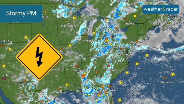
A stormy start to the work week will unfold for many parts of the Eastern U.S. The West, stays hot and sunny. All of these details are provided daily in the Weather & Radar daily briefing published every weekday at 5 a.m. ET .

The WeatherRadar will be the best tool to use today from the Mississippi and Ohio valleys eastward to the Atlantic Coast. Frequent afternoon thunderstorms will be possible for Detroit, Atlanta, Miami, Washington and New York. The Northeast will avoid the storms until later tonight into early Tuesday.

Stormy afternoon across the East.

Across southern Texas, a few tropical downpours are possible as the remnants of Barry move into northern Mexico. These could trigger flash flooding.

The central and northern Plains, Northwest and California will have plenty of sunshine. The Mountain West could have a few afternoon showers, so keep an eye on the WeatherRadar.

Summer is in full swing in the temperature department. Almost everywhere will be in the 80s and 90s with only the northern Plains in the 70s. Triple digits will bake the Southwest and interior southern California. Use the TemperatureRadar to see the temperatures in your area.

Tropical Update

The remnants of short-lived Tropical Storm Barry, formed in the western Gulf of Mexico late Sunday and dissipated over northern Mexico this morning, could bring some rain into southern Texas.

A stalled front over Florida will need to be watched for further development over the next several days, especially over the Atlantic northeast of Florida or in the northeast Gulf Coast.

News we are covering

  • July 4th preview

App news

Our hurricane alerts can help keep you prepared this hurricane season. Ensure you have downloaded the Weather & Radar app's latest version and turn on your alerts. Learn more here.

James West
More on the topic
Hurricane Polo remains dangerous. Active Pacific. . . Thursday, September 24, 2026
Thursday, September 24, 2026

Active Pacific

Hurricane Polo remains dangerous
All about nocturnal severe weather. Risks & preparedness. . . Saturday, September 5, 2026
Saturday, September 5, 2026

Risks & preparedness

All about nocturnal severe weather
10 facts about fog. Low clouds. . . Sunday, September 27, 2026
Fog impacting the Appalachian Mountains.
Sunday, September 27, 2026

Low clouds

10 facts about fog
All weather news
This might also interest you
Autumn cold front arrives. October cooldown spreads. . . Friday, October 2, 2026
Cold front brings cooler temperatures.
Friday, October 2, 2026

October cooldown spreads

Autumn cold front arrives
First hurricane of the Atlantic season. Isaias forms. . . Thursday, October 8, 2026
After a quiet start, the Atlantic's first hurricane has finally formed. Isaias is the latest first hurricane since the satellite era began in1966. With the Gulf Coast in sight, what impacts are expected?
Thursday, October 8, 2026

Isaias forms

First hurricane of the Atlantic season
Useful tips when driving in the rain. Flood safety. . . Saturday, October 3, 2026
Saturday, October 3, 2026

Flood safety

Useful tips when driving in the rain
All articles
Weather & Radar

Weather & Radar is also available on

Google Play StoreApp Store

Company

Contact us Privacy policy Legal info Accessibility statement

Services

Uploader

Socials

instagramfacebookthreadslinkList