Home
Weather New York
WeatherRadar
RainRadar
TemperatureRadar
WindRadar
LightningRadar
Weather News
Editor's Pick
Discover the app
Weather widget
Contact us
Apps
Career
    Home / Weather News /

    Daily briefing: West, Northeast stays busy

10:00 AM
December 23, 2025

Daily briefing
West, Northeast stay busy

Two winter storms, one arriving on the West Coast and another rolling across the Northeast, could bring some pre-holiday travel trouble. This is included in today's daily briefing published every weekday at 5 a.m. ET.

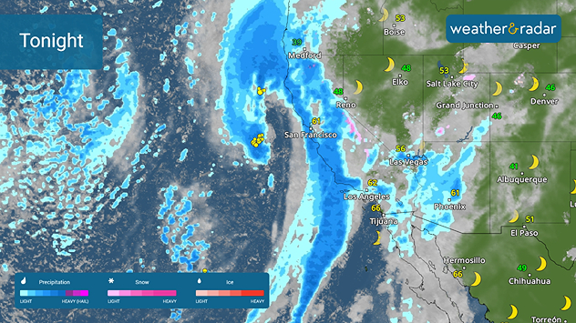
The string of recent West Coast rainmakers isn't going to end today. A new system — this one taking a more southerly path — will roll ashore today. The WeatherRadar shows the rain arriving this afternoon, with the heaviest rain moving into Los Angeles and San Francisco, later tonight and lasting through Wednesday. This will produce an increased flood risk.

West Coast tonight
Big storm heading onto the West Coast today.

The rain will also make its way into the Northwest later today too.

On the other side of the U.S., a quick-moving storm system will whip across the Ohio Valley, Mid-Atlantic and the Northeast. A quick burst of rain will sweep across the Ohio Valley and Mid-Atlantic while snow falls across the interior Northeast and southern New England. A couple of inches of snow will be possible in the interior mountains of the Northeast.

Between these two spots, the U.S. will have a quiet day ahead. The TemperatureRadar shows a "spring-like" warm up across the southern Plains, South and Southeast, where highs will be in the upper 60s and low 70s. Florida and southern Texas will be warmer with highs approaching 80 degrees.

Temperatures across the rest of the U.S. will be in the 40s, 50s and 60s with the northern Plains and Northeast in the teens and 20s.

App News

Finalizing holiday plans? Want to know how the Weather & Radar app can help? You can see all of our features at a glance using the Discover the App feature.

James West
More on the topic
High pressure & extreme heat. Why & how does it work?. . . Sunday, June 28, 2026
Sunday, June 28, 2026

Why & how does it work?

High pressure & extreme heat
El Niño is gaining momentum. Temperature records?. . . Thursday, May 7, 2026
The image shows the central Pacific in a computer model. A striking feature is the ocean coloured red, which indicates very warm seawater.
Thursday, May 7, 2026

Temperature records?

El Niño is gaining momentum
The only Blue Moon of the year rises. May astronomy outlook. . . Saturday, May 2, 2026
Saturday, May 2, 2026

May astronomy outlook

The only Blue Moon of the year rises
All weather news
This might also interest you
Saharan dust to reach Florida. Dry period expected. . . Tuesday, July 7, 2026
Saharan dust seen on the satllite image (right) moving westward toward Florida. Air quality impacts are expected.
Tuesday, July 7, 2026

Dry period expected

Saharan dust to reach Florida
Ring of fire developing. Storms encircle heat. . . Wednesday, July 1, 2026
Wednesday, July 1, 2026

Storms encircle heat

Ring of fire developing
Slow-moving storms and heavy rain. What to look for. . . Monday, July 6, 2026
Monday, July 6, 2026

What to look for

Slow-moving storms and heavy rain
All articles
Weather & Radar

Weather & Radar is also available on

Google Play StoreApp Store

Company

Contact us Privacy policy Legal info Accessibility statement

Services

Uploader

Socials

instagramfacebookthreadslinkList