Home
Weather New York
WeatherRadar
RainRadar
TemperatureRadar
WindRadar
LightningRadar
Weather News
Editor's Pick
Discover the app
Weather widget
Contact us
Apps
Career
    Home / Weather News /

    Flooding closes parts of PCH

04:59 PM
February 14, 2025

California deluge
Flooding closes parts of PCH

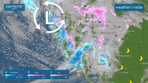
Southern California was swamped by heavy rain on Thursday as a powerful storm impacted the West Coast. A portion of the Pacific Coast Highway (PCH) between Malibu and Santa Monica, Calif., was closed due to debris flows along burn scars.

Torrential downpours and heavy mountain snow swamped the state of California on Thursday as a powerful atmospheric river impacted the Golden State.

The heavy rain led to dangerous flash flooding along recent burn scars created by the historic wildfires in Southern California earlier in the year. The video above shows the destruction on and near the Pacific Coast Highway and in the Las Flores neighborhood of Malibu.

How to turn on weather alertsread more

This same storm will move east today and into the weekend, bringing the threat of snow, heavy rain and severe weather. Learn more by reading today's Breakfast Brief.

Mary Mays
More on the topic
Super Typhoon Near the Philippines. Gusts up to 155. . . Tuesday, June 23, 2026
Tuesday, June 23, 2026

Gusts up to 155

Super Typhoon Near the Philippines
How does fog form?. Multiple ways. . . Saturday, July 11, 2026
Saturday, July 11, 2026

Multiple ways

How does fog form?
Super Typhoon Bavi threatens Taiwan. 155 mph winds. . Weather Videos. Wednesday, July 8, 2026
The image shows an intense tropical cyclone over the western Pacific, east of Taiwan and the Philippines. The centre of the system is depicted as a light purple and white vortex with a clearly visible eye, surrounded by a ring of red and orange areas indicating the strongest wind speeds. A white arrow marks the typhoon’s predicted track towards the north-west, in the direction of Taiwan. To the west of the storm lie the Philippines, with the cities of Manila and Cebu; to the north of these lies Taiwan, with Taipei. Further west, the Chinese coast, including Hong Kong, and parts of Vietnam can be seen. The coloured wind map shows predominantly green areas outside the storm’s core, indicating significantly weaker winds. White streamlines illustrate the typhoon’s anti-clockwise circulation in the Northern Hemisphere. The highest wind speeds are concentrated around the eye of the cyclone.
Weather VideosWednesday, July 8, 2026

155 mph winds

Super Typhoon Bavi threatens Taiwan
All weather news
This might also interest you
Lopsided Bertha moves west. Who sees the impacts. . . Thursday, July 23, 2026
Thursday, July 23, 2026

Who sees the impacts

Lopsided Bertha moves west
Be prepared for wildfires. By using the app. . . Saturday, July 18, 2026
Wildfires can spark anywhere, anytime. The Weather & Radar app can help you determine your area's risk.
Saturday, July 18, 2026

By using the app

Be prepared for wildfires
Dangerous air quality continues. Canada wildfires smoke. . . Friday, July 17, 2026
Smoky Philadelphia
Friday, July 17, 2026

Canada wildfires smoke

Dangerous air quality continues
All articles
Weather & Radar

Weather & Radar is also available on

Google Play StoreApp Store

Company

Contact us Privacy policy Legal info Accessibility statement

Services

Uploader

Socials

instagramfacebookthreadslinkList