Home / Editor's Pick /

Florida's tropical rains - Florida's tropical rains

12:10 PM
June 10, 2024

Florida's tropical rains
Flooding: Fine-tuned timing & rainfall

Recommended external content from YouTube

We need your consent to show content from YouTube. You can withdraw your consent at any time.

I agree that content from YouTube will be displayed to me.

Settings for external content

Privacy policy
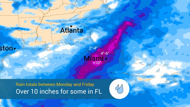
Timing is more finetuned for this week’s heavy rain event impacting parts of Florida. Some areas will likely deal with high flood risk as up to 10 inches of rain is possible. Let’s dive into the forecast.

Deep tropical moisture arrives from the western Caribbean. This tropical moisture has been causing heavy rains over the Greater Antilles, where the ground has been very saturated from recent rains. The heavy rains will continue to affect Cuba, Haiti, and the Bahamas to start the week. By Tuesday, some moisture will migrate over to South Florida, and drench the state gradually as the bands of showers and thunderstorms move mostly from south to north. By Wednesday the entire state will have already received several rounds of rain.

Rainfall through Friday.Rainfall through Friday.

How much rain?

We continue to forecast the highest rain amounts to fall over the Southern half of the Peninsula. Rainfall will help put a big dent in areas dealing with drought but unfortunately, it might come too much, too fast, and create flooding problems. Some areas across South Florida could receive up to 10 inches of rain. Generally, rainfall amounts will range between 3 and 6 inches.

Central Florida, including the Tampa Bay area, along the I-4 corridor through the Space Coast could receive between 2 and 4 inches, with the higher range likely falling south of I-4. For North Florida and the Panhandle, rainfall will arrive first due to a cold front meandering at the beginning of the week, very isolated, with more intense and constant showers courtesy of the deep tropical moisture that will inevitably arrive by the end of the week. Rainfalls could vary, depending on how much moisture finally arrives up north.

We are closely monitoring this situation and will continue to bring you updates. Please review your area, and make sure not to cross, drive, or walk through flood waters. The water could be deeper than expected, and floodwaters could be contaminated, have sharp objects, or dangerous animals.

Irene Sans
More on the topic
storm surge sandy
Saturday, September 27, 2025

The deadliest threat

How to stay safe from storm surge
setting-sun
Saturday, September 6, 2025

Coldest time of the day

Lowest temperature is just after sunrise
Man sits with telescope looking up at the Milky Way.
Sunday, September 7, 2025

September astro outlook

Equinox dominates the month
All weather news
This might also interest you
Tuesday, October 28, 2025

Daily briefing

Active Tuesday ahead for many
Friday, October 24, 2025

Texas and the Southeast

Multi-day flood threat
Hurricane Melissa is an intense Category 5 storm with sustained winds of 185 mph, making it one of the most intense on record. Jamaica is bracing for torrential rain, hurricane-force winds, dangerous landslides and life-threatening storm surge.
Tuesday, October 28, 2025

All eyes on Jamaica

Tracking intense Hurricane Melissa
All articles
Weather & Radar

www.weatherandradar.com

instagramfacebookthreadsContact uslinkList
Privacy policy | Legal info | Accessibility statement