Home
Weather New York
WeatherRadar
RainRadar
TemperatureRadar
WindRadar
LightningRadar
Weather News
Editor's Pick
Discover the app
Weather widget
Contact us
Apps
Career
Home / Weather News /

Friday's live blog: Tornado emergenct declared amid severe storm outbreak

08:29 PM
April 26, 2024

Friday's live blog
Monster wedge tornado leaves destruction

Recommended external content from YouTube

We need your consent to show content from YouTube. You can withdraw your consent at any time.

I agree that content from YouTube will be displayed to me.

Settings for external content

Privacy policy

^^^^LIVE STREAM^^^^

Severe storms have been ongoing since Thursday as a strong low pressure impacts the Plains. Tornadoes, damaging winds, hail, and flooding are all expected. This live blog will be updated throughout the day to bring you the latest information.

6:00 p.m. CDT

Severe thunderstorms are expected to persist and advance northeastward across the Plains throughout the afternoon and into the evening. The potential for tornado formation is set to increase as night falls, further exacerbating the already perilous conditions.

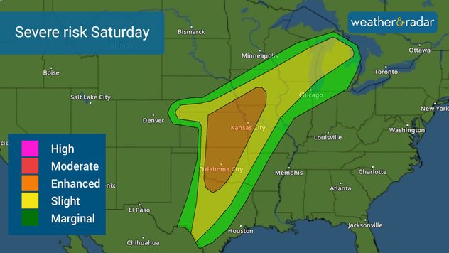
svr weather risk saturdaySevere weather risk continues into Saturday. Continue to follow Weather & Radar for the latest information. You can also track the storms LIVE on our interactive WeatherRadar.

5:30 p.m. CDT

A rain-wrapped tornado was spotted by Weather & Radar storm chasers just north of Redfield, Miss. Rain-wrapped tornadoes are tornadoes that are often camouflaged or hidden within heavy rain. They can be as equally powerful as a non-rain-wrapped tornado, but can often be more dangerous as they are harder to see. You can follow along the chase in the live stream feed at the top of this blog.

5:00 p.m. CDT

Reports continue on social media of a large wedge tornado tracking northwest across Council Bluffs, Omaha. This is a very dangerous tornado impacting residential areas. People in the affected areas are urged to seek shelter immediately.

4:30 p.m. CDT

A wedge tornado has left a trail of destruction in Elkhorn, just west of Relevant Community Church. Emergency rescue teams are rushing to the scene.

4:00 p.m. CDT

Tornado Emergency continues for Blair, Neb., Missouri Valley, Iowa, and Fort Calhoun, Neb. until 4:30 p.m. CDT amid reports of a large and destructive wedge tornado ripping across residential communities.

3:30 p.m. CDT

BREAKING: A Potentially Dangerous Situation (PDS) Tornado Warning is active in Lincoln, Neb. Check out the footage below for this monster of a tornado! Storm chasers rush to the rescue after tornado flips semi-truck on interstate.

3:00 p.m. CDT

Timing is everything today when it comes to being prepared for the severe weather headed in your direction. Heads up in Iowa as the storm line makes it in throughout the afternoon and evening hours.

2:30 p.m. CDT

Meteorologist Mary Mays was just live going over the severe storm threat. See the replay below to get the latest information!

12:30 p.m. CDT

Clearing skies means more energy to support storm development this afternoon. Another tornado watch is expected soon, but this time up in eastern Nebraska as the sun begins to shine and the clouds move away.

11:30 a.m. CDT

Many of these Texas storms are packing a lightning-filled punch and are moving into heavy residential areas. Keep your eyes on the sky.

10:30 a.m. CDT

It's going to be a busy day! The next tornado watch has been issued for northeast Texas as storms tap into the available energy and temperatures rise. Have at least three ways to receive a warning! The lunch hour is coming up...

Dallas, Waco, and Tyler, Texas, residents need to be on alert.

10:00 a.m. CDT

A tornado watch has been issued as severe storms ramp up early this morning.

9:00 a.m. CDT

An enhanced risk for severe weather has been issued in the central Plains and mid-Mississippi Valley, with a slight risk extending all the way down to Texas. Severe storms have been happening since yesterday and during the overnight hours as a slow-moving system slams the central U.S.

Have your alerts switched on and have at least three ways to receive a weather warning.

Becca Parker
More on the topic
Thursday, January 1, 2026

The start of 2026

Happy New Year!
Smooth, lens-shaped lenticular cloud hovering against a blue sky, with a distinct flattened oval form and soft layered edges, standing out from thinner clouds nearby.
Saturday, January 17, 2026

Lenticular clouds

"Flying saucers" over Wales
Winter weather impacts Minneapolis.
Saturday, December 27, 2025

Build your emergency kit

Stuck in a snow storm survival kit
All weather news
This might also interest you
Sunday, January 18, 2026

Unusual wintry weather

Snow for the South
Split image of freezing rain turned to ice over street lamps and infographic describing the different precipitation types.
Sunday, January 18, 2026

Snow, sleet, graupel...

The different winter precipitation types
Tuesday, January 20, 2026

This weekend

Major winter storm to target South
All articles
Weather & Radar
US
Clima & Radar Brasil
Hava durumu & Radar Türkiye
Időjárás és Radar Magyarország
Καιρός & Ραντάρ Ελλάδα
Météo & Radar Belgique (Français)
Météo & Radar France
Meteo & Radar Italia
Meteo & Radar România
Météo & Radar Suisse (Français)
Meteo & Radars Latvija
OrasOnline Lietuva
Počasí & Radar Czechia
Počasie & Radar Slovensko
Pogoda & Radar Polska
Погода & Радар Україна (українська)
Tempo & Radar Portugal
Tiempo & Radar Argentina
Tiempo & Radar España
Vejr & Radar Danmark
Vreme & Radar Slovenija
Vreme & Radar Srbija
Vrijeme & Radar Bosna
Vrijeme & Radar Crna Gora
Vrijeme & Radar Hrvatska
Време & Радар България
Времето & Радар Macedonia
Weather & Radar India (English)
Weather & Radar Ireland
Weather & Radar United Kingdom
Weather & Radar USA (Español)
Weer & Radar België (Nederlands)
Weer & Radar Nederland

Weather & Radar is also available on

Google Play StoreApp Store

Company

Contact us Privacy policy Legal info Accessibility statement

Services

Uploader

Socials

instagramfacebookthreadslinkList