Home
Weather New York
WeatherRadar
RainRadar
TemperatureRadar
WindRadar
LightningRadar
Weather News
Editor's Pick
Discover the app
Weather widget
Contact us
Apps
Career
    Home / Weather News /

    Front brings chill, but no rain

09:43 PM
January 13, 2026

Up and down in Texas
Front brings chill, but no rain

The first front will pass on Wednesday; the second, on Friday.

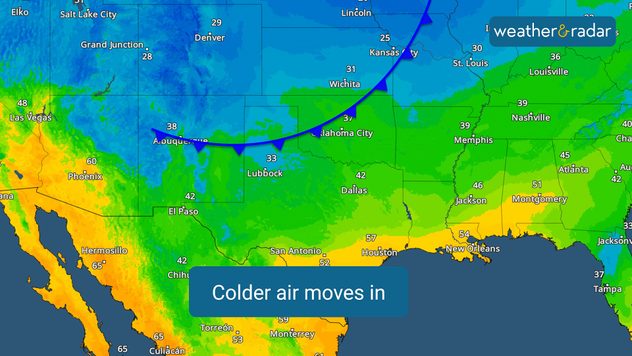
A series of cold fronts will bring a roller coaster of temperatures this week and into the weekend. It's important to note that both fronts will be dry, but don't let the changes catch you by surprise; stay informed.

The rain that has been present today in several Texas cities, such as San Antonio and Austin, this morning, and across Southeast Texas this afternoon will gradually dissipate. Some scattered showers will still be possible in North Texas on Tuesday night, but generally, we will see a trend toward less cloud cover.

The first cold front will move through East Texas on Wednesday. While the western half of the state, from I-35 westward, will experience temperatures slightly above normal, the eastern half, including Houston, will see temperatures up to 7 degrees below normal. Highs in Houston will remain in the upper 50s. The Dallas-Fort Worth Metroplex will experience a dramatic temperature difference, with temperatures potentially varying by as much as 15 degrees between Tyler and Fort Worth.

The second cold front will arrive on Friday. More cities in the west will experience cooler temperatures, but mostly in the mornings, when temperatures will be near or slightly below average. The cold air mass will move eastward, and by Monday, almost the entire state will see afternoon temperatures in the 60s, near or slightly above normal for this time of year.

Houston

Mo
75
85
Tu
80
91
We
80
88
Th
73
89
Fr
71
88
Sa
69
85
Su
62
80
Mo
64
79
Tu
64
80
We
65
81
Th
67
83
Fr
68
85
Sa
66
83
Su
65
82
Max (°F)
Min (°F)
moreless

Irene Sans
More on the topic
Hawaii's second 2026 hurricane impact. Hurricane Lowell. . . Tuesday, September 8, 2026
Tuesday, September 8, 2026

Hurricane Lowell

Hawaii's second 2026 hurricane impact
The average first frosts in the U.S.. Meteorological autumn. . . Sunday, October 4, 2026
First frosts can begin in September as autumn temps move in.
Sunday, October 4, 2026

Meteorological autumn

The average first frosts in the U.S.
Hurricane parade in the Pacific. Karina is very strong. . Weather Videos. Tuesday, September 1, 2026
WindRadar for Friday, showing the three hurricanes – Lowell, Karina and Maria – over the Pacific.
Weather VideosTuesday, September 1, 2026

Karina is very strong

Hurricane parade in the Pacific
All weather news
This might also interest you
Be ready for tropical activity. Tips & tools. . . Wednesday, October 7, 2026
Track hurricanes with the WeatherRadar
Wednesday, October 7, 2026

Tips & tools

Be ready for tropical activity
Tropical downpours for the West. Rachel's remnants. . . Sunday, October 11, 2026
Not just one, but two post-tropical systems are bringing a deluge to the U.S. this weekend. Moisture from the remnants of Tropical Storm Rachel will bring downpours to parts of the West into early next week.
Sunday, October 11, 2026

Rachel's remnants

Tropical downpours for the West
When a hurricane is on the way.... You can be ready!. . . Thursday, October 8, 2026
Thursday, October 8, 2026

You can be ready!

When a hurricane is on the way...
All articles
Weather & Radar

Weather & Radar is also available on

Google Play StoreApp Store

Company

Contact us Privacy policy Legal info Accessibility statement

Services

Uploader

Socials

instagramfacebookthreadslinkList