Home
Weather New York
WeatherRadar
RainRadar
TemperatureRadar
WindRadar
LightningRadar
Weather News
Editor's Pick
Discover the app
Weather widget
Contact us
Apps
Career
    Home / Weather News /

    Hurricane season - Three common misperceptions

11:00 AM
August 17, 2025

Hurricane season
Three common misperceptions

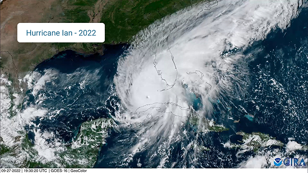
Hurricane Ian (2022) satellite imagery before SWFL landfall.
Hurricane Ian (2022) satellite imagery before SWFL landfall. - © NOAA

When it comes to tropical weather, we often make our decisions based on past experiences and perhaps misunderstandings. We'll address some common misperceptions so you have more knowledge to make decisions as we navigate the latest hurricane season.

"Nothing bad happened the last time a hurricane hit my area."

Every hurricane is unique. Experiencing a hurricane once doesn't mean it will be exactly like that the next time. If it was the heavy rains last time, it might be the storm surge this time. It's the luck of the draw depending on the size, strength of winds, direction of impact, etc.

Recommended external content from YouTube

We need your consent to show content from YouTube. You can withdraw your consent at any time.

I agree that content from YouTube will be displayed to me.
Privacy policy
Hurricane Ian didn't make landfall on Sanibel or Captiva islands, but the worst of the hurricane's impacts were found there.

"This hurricane is very small compared to other ones I've been through."

While the hurricane may be small in diameter, it can still pack a punch. Even the smallest hurricanes can reach maximum category strength.

Did you know Category 5 Hurricane Andrew's hurricane-force winds only extended 100 miles in diameter? Its size was not the issue; it was mostly the dangerous but compact winds that caused $63 billion (today's dollars) in damage, wiping homes off their foundations.

"It's only a Tropical Storm/Category 1 Hurricane. I have nothing to worry about!"

Each hurricane category only addresses the wind strength. That leaves flooding rains, storm surge, rip currents and severe weather, like tornadoes, out of the picture. It's important to pay attention to all the information about a tropical storm or hurricane because the winds may be the least of your worries.

Remember Tropical Storm Alex from 2022? Maybe not under that title specifically, but you may remember its South Florida impacts as Potential Tropical Cyclone 1! Many locations across South Florida received at least 10 inches of rain, causing dangerous flooding, and this was all before Alex became an organized tropical storm.

Have you caught yourself saying any of these statements before? Keep yourself up-to-date with our tropical updates, published each weekday in the Daily Briefing.

Mary Mays
More on the topic
El Niño is gaining momentum. Temperature records?. . . Thursday, May 7, 2026
The image shows the central Pacific in a computer model. A striking feature is the ocean coloured red, which indicates very warm seawater.
Thursday, May 7, 2026

Temperature records?

El Niño is gaining momentum
Longest day of the year is here. Summer solstice. . . Sunday, June 21, 2026
Sunday, June 21, 2026

Summer solstice

Longest day of the year is here
Super Typhoon Bavi threatens Taiwan. 155 mph winds. . Weather Videos. Wednesday, July 8, 2026
The image shows an intense tropical cyclone over the western Pacific, east of Taiwan and the Philippines. The centre of the system is depicted as a light purple and white vortex with a clearly visible eye, surrounded by a ring of red and orange areas indicating the strongest wind speeds. A white arrow marks the typhoon’s predicted track towards the north-west, in the direction of Taiwan. To the west of the storm lie the Philippines, with the cities of Manila and Cebu; to the north of these lies Taiwan, with Taipei. Further west, the Chinese coast, including Hong Kong, and parts of Vietnam can be seen. The coloured wind map shows predominantly green areas outside the storm’s core, indicating significantly weaker winds. White streamlines illustrate the typhoon’s anti-clockwise circulation in the Northern Hemisphere. The highest wind speeds are concentrated around the eye of the cyclone.
Weather VideosWednesday, July 8, 2026

155 mph winds

Super Typhoon Bavi threatens Taiwan
All weather news
This might also interest you
Saharan dust to reach Florida. Dry period expected. . . Tuesday, July 7, 2026
Saharan dust seen on the satllite image (right) moving westward toward Florida. Air quality impacts are expected.
Tuesday, July 7, 2026

Dry period expected

Saharan dust to reach Florida
Slow-moving storms and heavy rain. What to look for. . . Monday, July 6, 2026
Monday, July 6, 2026

What to look for

Slow-moving storms and heavy rain
Turning hot this weekend. Brutal temps across West. . . Friday, July 10, 2026
Saturday & Sunday's highs
Friday, July 10, 2026

Brutal temps across West

Turning hot this weekend
All articles
Weather & Radar

Weather & Radar is also available on

Google Play StoreApp Store

Company

Contact us Privacy policy Legal info Accessibility statement

Services

Uploader

Socials

instagramfacebookthreadslinkList