Home
Weather New York
WeatherRadar
RainRadar
TemperatureRadar
WindRadar
LightningRadar
Weather News
Editor's Pick
Discover the app
Weather widget
Contact us
Apps
Career
    Home / Weather News /

    Lasting overnight - Round two for Midwest, Plains severe storms

06:44 PM
April 3, 2026

Lasting overnight
Round two for Midwest, Plains severe storms

Not 24 hours after a spring storm brought tornadic supercells through the Midwest, another storm is on its heels, bringing a similar threat.

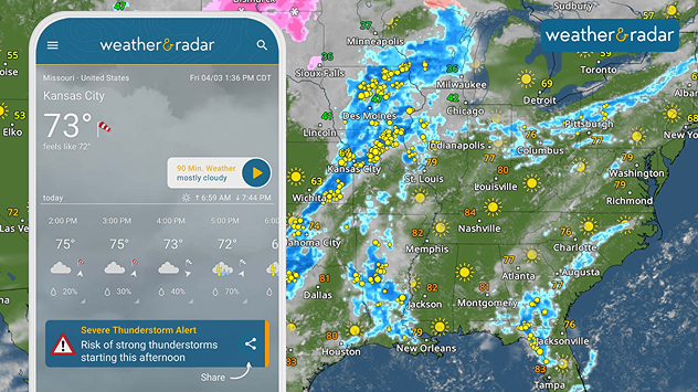
An enhanced risk, a level three out of five on the severity scale, has been issued for places like Hannibal and St. Joseph, Mo., Burlington and Ottumwa, Iowa, and Macomb, Ill., but severe storms could occur anywhere between west Texas to central Wisconsin and eastward into Pennsylvania.

The WeatherRadar shows storms really kicking off around the mid-afternoon hours local time, and becoming more widespread during the PM commute and through Friday night plans. Many from Michigan to the southern Plains could be woken up overnight by thunder.

Severe weather is in the forecast. Turn your app alerts on!

Residents should have a severe weather plan ready to go in case a warning is issued for your location, especially if there is a tornado. Have your app alerts turned on to receive info about the coming line of storms, and your notifications volume turned up in case severe storms move through your area while you're asleep.

Have you seen our new app feature?read more

Becca Parker
More on the topic
Super Typhoon Bavi threatens Taiwan. 155 mph winds. . Weather Videos. Wednesday, July 8, 2026
The image shows an intense tropical cyclone over the western Pacific, east of Taiwan and the Philippines. The centre of the system is depicted as a light purple and white vortex with a clearly visible eye, surrounded by a ring of red and orange areas indicating the strongest wind speeds. A white arrow marks the typhoon’s predicted track towards the north-west, in the direction of Taiwan. To the west of the storm lie the Philippines, with the cities of Manila and Cebu; to the north of these lies Taiwan, with Taipei. Further west, the Chinese coast, including Hong Kong, and parts of Vietnam can be seen. The coloured wind map shows predominantly green areas outside the storm’s core, indicating significantly weaker winds. White streamlines illustrate the typhoon’s anti-clockwise circulation in the Northern Hemisphere. The highest wind speeds are concentrated around the eye of the cyclone.
Weather VideosWednesday, July 8, 2026

155 mph winds

Super Typhoon Bavi threatens Taiwan
How does fog form?. Multiple ways. . . Saturday, July 11, 2026
Saturday, July 11, 2026

Multiple ways

How does fog form?
High pressure & extreme heat. Why & how does it work?. . . Sunday, July 12, 2026
Sunday, July 12, 2026

Why & how does it work?

High pressure & extreme heat
All weather news
This might also interest you
How does a hurricane form?. Hurricane preparedness. . . Sunday, July 19, 2026
hurricane maria
Sunday, July 19, 2026

Hurricane preparedness

How does a hurricane form?
Be prepared for wildfires. By using the app. . . Saturday, July 18, 2026
Wildfires can spark anywhere, anytime. The Weather & Radar app can help you determine your area's risk.
Saturday, July 18, 2026

By using the app

Be prepared for wildfires
Northern New England storms. Rare severe threat. . . Tuesday, July 14, 2026
Tuesday, July 14, 2026

Rare severe threat

Northern New England storms
All articles
Weather & Radar

Weather & Radar is also available on

Google Play StoreApp Store

Company

Contact us Privacy policy Legal info Accessibility statement

Services

Uploader

Socials

instagramfacebookthreadslinkList