Home / Weather News /

Monday's live blog: Monday's live blog

04:33 PM
February 19, 2024

Monday's live blog
More storms to soak California

An atmospheric river will bring more rain, heavy snow, gusty winds, and coastal flooding to California. This live blog will keep you up-to-date on the latest threats.

7:45 p.m. ET/4:45 p.m. PT

More heavy rain will impact Southern California on Tuesday. Weather & Radar's expert meteorologists will be ready with the latest forecast.

6:45 p.m. ET/3:45 p.m. PT

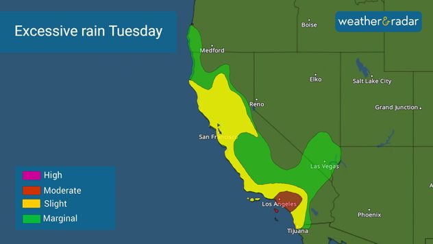
A moderate risk for excessive rain is now in place for Tuesday. More flooding is possible, especially in southern California. Check in with Weather & Radar for the latest information throughout the day tomorrow.

Excessive rain Tuesday

5:45 p.m. ET/2:45 p.m. PT

Evacuations are in place in Santa Barbara County for properties along waterways associated with the Alisal burn area and some areas along Sycamore Creek and Mission Creek in the city of Santa Barbara.

5:15 p.m. ET/2:15 p.m. PT

The Santa Barbara Airport is closed due to flooding on the airfield. Commercial flights have been canceled, and general aviation operations have been paused.

4:15 p.m. ET/1:15 p.m. PT

Parts of southern California have seen more than half a foot of rain over the last 48 hours. With more rain on the way, flash flooding remains a concern.

3:45 p.m. ET/12:45 p.m. PT

Power outages are starting to grow across California. Currently, 14,173 customers are without power.

2:45 p.m. ET/11:45 a.m. PT

Meteorologist Becca Parker will have the latest forecast live on YouTube at 3 p.m. ET/12:00 p.m. PT.

2:15 p.m. ET/11:15 a.m. PT

Heavy snow hit the Sierra Nevada overnight, plastering everything with a wet snow and causing local power outages. Here is a view of the wintry scene from near Truckee, Calf.

Sierra snowSierra SnowSierra snowSierra snow Atmospheric river eventwet snow
1/6
CALTRAN road crew work to keep Interstate 80 open over Donner Pass in the Sierra Nevada Monday, February 19.

1:30 p.m. ET/10:30 a.m. PT

High surf, strong rip currents and coastal flooding are concerns along the California coastline. Coastal residents should prepare for possible flooding.

12:30 p.m. ET/9:30 a.m. PT

In addition to the flooding threat, a few strong storms may break out in central California today. There is a slight risk, a level two out of five, of severe weather across parts of the Sacramento Valley. The strongest storms this afternoon will be capable of a tornado or two along with isolated marginal hail and damaging winds.

11:30 a.m. ET/8:30 a.m. PT

Heavy snow is already causing issues in the Sierras. Chain controls are now in place for Donner Pass. Jonathan Petramala is in the Sierras with reports for Weather & Radar throughout the day.

Weather & Radar USA editorial team
More on the topic
Man sits with telescope looking up at the Milky Way.
Sunday, September 7, 2025

September astro outlook

Equinox dominates the month
Sunday, August 24, 2025

Sun & moon info

Your all-in-one astronomy tool
On the left, a satellite image of a hurricane over the sea; on the right, a man in a clearance vehicle clearing debris and food in a flooded supermarket.
Friday, August 29, 2025

Twenty years ago today

Hurricane Katrina hit Gulf Coast
All weather news
This might also interest you
Hurricanes approaching the coastline can cause extensive impacts, including flooding, even before landfall.
Saturday, September 13, 2025

Knowledge is power

What to know this hurricane season
Saturday, September 13, 2025

Flood safety

Useful tips when driving in the rain
Monday, September 15, 2025, Daily Briefing
Monday, September 15, 2025

Daily briefing

Summer heat returns
All articles
Weather & Radar

www.weatherandradar.com

instagramfacebookthreadsContact uslinkList
Privacy policy | Legal info | Accessibility statement