Home
Weather New York
WeatherRadar
RainRadar
TemperatureRadar
WindRadar
LightningRadar
Weather News
Editor's Pick
Discover the app
Weather widget
Contact us
Apps
Career
    Home / Weather News /

    Moon and Mars conjuction

10:45 PM
February 10, 2025

Will you see it?
Moon and Mars conjuction

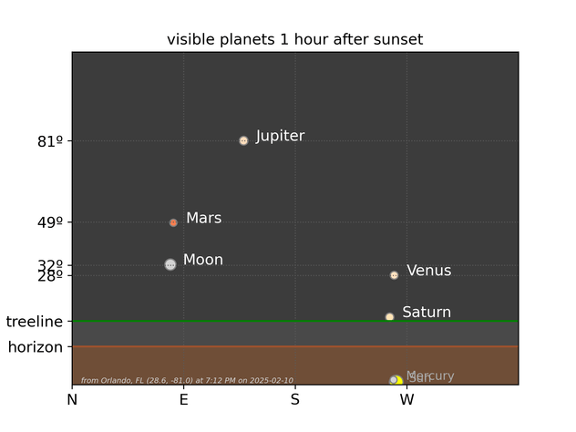
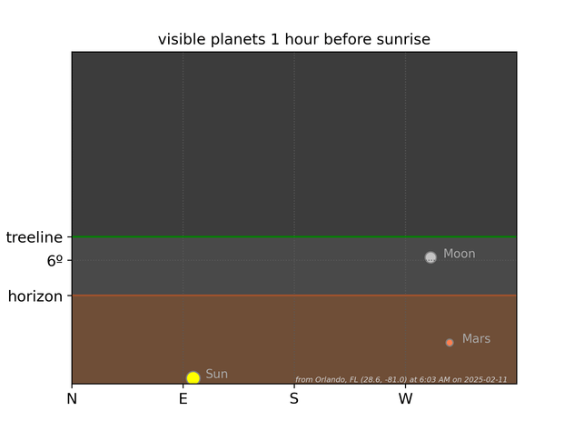
There is a chance you can see a great conjunction in the skies this week between Mars and the Moon.

The Moon is shining bright during most of the week (if clouds permit), and there are several planets you might be able to spot in the sky too easily! You will notice Jupiter, Venus-- the brightest -- and Mars, which will be closer to the Moon. Of course, not technically, but visually for you. For reference, Mars is 145 times farther from Earth than the Moon; the minimum distance (due to orbit) that the Moon can be from Mars is 238,855 miles.

1/2

The Moon reaches its full phase on February 12 at 7:53 am Central Time. Now it's up to your local weather. Could clouds obstruct your visibility? For how long? Ensure you are looking up and have the WeatherRadar handy to time out the clouds in your area. The astronomical section in our app also has excellent information about sunrise and sunset times and the Moon phase.

Irene Sans
More on the topic
Super Typhoon Near the Philippines. Gusts up to 155. . . Tuesday, June 23, 2026
Tuesday, June 23, 2026

Gusts up to 155

Super Typhoon Near the Philippines
Super Typhoon Bavi threatens Taiwan. 155 mph winds. . Weather Videos. Wednesday, July 8, 2026
The image shows an intense tropical cyclone over the western Pacific, east of Taiwan and the Philippines. The centre of the system is depicted as a light purple and white vortex with a clearly visible eye, surrounded by a ring of red and orange areas indicating the strongest wind speeds. A white arrow marks the typhoon’s predicted track towards the north-west, in the direction of Taiwan. To the west of the storm lie the Philippines, with the cities of Manila and Cebu; to the north of these lies Taiwan, with Taipei. Further west, the Chinese coast, including Hong Kong, and parts of Vietnam can be seen. The coloured wind map shows predominantly green areas outside the storm’s core, indicating significantly weaker winds. White streamlines illustrate the typhoon’s anti-clockwise circulation in the Northern Hemisphere. The highest wind speeds are concentrated around the eye of the cyclone.
Weather VideosWednesday, July 8, 2026

155 mph winds

Super Typhoon Bavi threatens Taiwan
High pressure & extreme heat. Why & how does it work?. . . Sunday, July 12, 2026
Sunday, July 12, 2026

Why & how does it work?

High pressure & extreme heat
All weather news
This might also interest you
Intense rain for the Northeast. Flooding possible. . . Tuesday, July 28, 2026
Tuesday, July 28, 2026

Flooding possible

Intense rain for the Northeast
Useful tips when driving in the rain. Flood safety. . . Saturday, August 1, 2026
Saturday, August 1, 2026

Flood safety

Useful tips when driving in the rain
Dry vegetation, low humidity and winds. The perfect fire recipe. . . Sunday, July 26, 2026
Sunday, July 26, 2026

The perfect fire recipe

Dry vegetation, low humidity and winds
All articles
Weather & Radar

Weather & Radar is also available on

Google Play StoreApp Store

Company

Contact us Privacy policy Legal info Accessibility statement

Services

Uploader

Socials

instagramfacebookthreadslinkList