Home
Weather New York
WeatherRadar
RainRadar
TemperatureRadar
WindRadar
LightningRadar
Weather News
Editor's Pick
Discover the app
Weather widget
Contact us
Apps
Career
    Home / Weather News /

    No cool break for muggy Florida

11:00 AM
February 2, 2025

Cold front retracts
No cool break for Florida

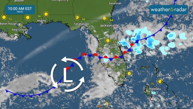
Florida might be hoping for another cooldown, but the same front that brought rain over the Appalachians has lost its punch and will start to retract over Central Florida on Sunday. Temperatures will remain above average.

Muggy and toasty weather is set to continue as the front loses its energy over Central Florida. Our WeatherRadar shows rain still present in the morning hours on Sunday, mainly across Central Florida. The skies will remain partly to mostly cloudy at times as the front tries to fizzle out. It is attached to another low-pressure system that will likely cross the state on Monday morning but will not bring much relief to the heat. Highs across South Florida will be in the low-80s.

1/2
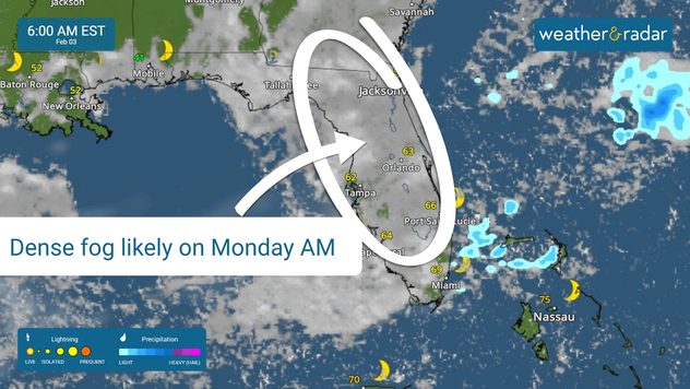
Lots of moisture is available in the atmosphere, and temperatures drop to saturation, forming low clouds, also known as fog Monday morning.

Overall, Sunday will remain a bit unstable in the morning hours. Partly cloudy skies in the afternoon and temperatures warm and feeling muggy. There will be so much moisture in the atmosphere that as the temperatures drop in the evening and overnight into Monday morning, they will reach saturation, creating dense fog for many areas across North and Central Florida, especially along the interior and the suburban regions.

Driving when foggyread more

Make sure to keep a safe distance from cars on Monday morning and use your low beams as they reflect less light, not obstructing visibility more. Those living near the coast might not see fog, especially if you wake up well after sunrise. If there were any fog, it would likely be dissipated by then. But many will likely encounter dense, patchy fog spots as they commute. It's always a fascinating view for many early risers Floridians.

Irene Sans
More on the topic
Rip currents & safety tips. As more head to the coast. . . Saturday, July 25, 2026
rip current
Saturday, July 25, 2026

As more head to the coast

Rip currents & safety tips
High pressure & extreme heat. Why & how does it work?. . . Sunday, July 12, 2026
Sunday, July 12, 2026

Why & how does it work?

High pressure & extreme heat
Meteorological summer is here!. Bye, spring!. . . Monday, June 1, 2026
Monday, June 1, 2026

Bye, spring!

Meteorological summer is here!
All weather news
This might also interest you
Gulf system is becoming better organized. It moves slowly. . . Monday, July 20, 2026
Monday, July 20, 2026

It moves slowly

Gulf system is becoming better organized
Temps 15-degrees below average. Big cold front. . . Wednesday, July 22, 2026
Wednesday, July 22, 2026

Big cold front

Temps 15-degrees below average
Multi-Day flood threat for Mid-Atlantic. Stalled front. . . Wednesday, July 22, 2026
Wednesday, July 22, 2026

Stalled front

Multi-Day flood threat for Mid-Atlantic
All articles
Weather & Radar

Weather & Radar is also available on

Google Play StoreApp Store

Company

Contact us Privacy policy Legal info Accessibility statement

Services

Uploader

Socials

instagramfacebookthreadslinkList