Home
Weather New York
WeatherRadar
RainRadar
TemperatureRadar
WindRadar
LightningRadar
Weather News
Editor's Pick
Discover the app
Weather widget
Contact us
Apps
Career
    Home / Editor's Pick /

    Oklahoma: rare high risk - Violent, long-tracked tornadoes likely

02:04 PM
May 6, 2024

Oklahoma: rare high risk
Violent, long-tracked tornadoes likely

It’s May, and the spring season continues in full force. We start the week talking about the chance for long-tracked tornadoes and very large hail. Let’s dive into the forecast.

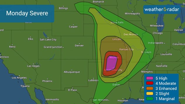
Almost 2 million people are at risk of experiencing the worst weather on Monday. The Storm Prediction Center upgraded the risk of severe weather to the highest category, 5 out of 5 for Oklahoma City, Norman, Midwest City, Okla., and Moore, Okla. A high risk is rare, which means that a violent severe outbreak is almost guaranteed. Cities across central Oklahoma and south-central Kansas are at a level 4 of 5 on the severity scale, moderate, where numerous long-tracked tornadoes are possible. But severe storms could affect an extra 13 million people from Nebraska through North Texas and parts of the Midwest.

Severe weather outbreak likely in the Central and Southern Plains on May 6, 2024.

All ingredients are there to start this week with a big severe weather outbreak. In the middle and upper levels of the atmosphere, there will be a low pressure that will inject lots of instability into the atmosphere as it leaves the Rockies to the east. Tapping into all this instability will be deep moisture coming in from the Gulf of Mexico and meeting right over the Central and Southern Plains.

The biggest threat will be very large hail that could measure more than 3 inches in diameter, winds of at least 80 mph, and violent tornadoes that can be long-tracked.

The timing of severe storms

Monday afternoon the storms will ignite, moving to the east throughout the evening, most likely causing big troubles and damage. Our WeatherRadar shows the showers starting across the central region of Oklahoma, including over Oklahoma City after 1 p.m. CT. Still, the strongest storms will cross the state's capital between 5 p.m. and midnight central time. Dallas-Fort Worth will also have the chance for isolated severe storms after 3 p.m. while two lines of severe storms will be likely to affect the Ozarks, including Kansas City.

We will continue to bring you updates throughout the day, please check back with the latest and make sure you have your weather alerts on. Our weather reporter Jonathan Petramala is in Oklahoma and will bring you prompt updates from location.

Irene Sans
More on the topic
Waterspouts possible, what are they?. They can be dangerous. . . Saturday, July 11, 2026
Waterspouts weatherradar.
Saturday, July 11, 2026

They can be dangerous

Waterspouts possible, what are they?
Record-breaking heatwave in Europe. Hotter than most of U.S.. . . Thursday, June 25, 2026
Thursday, June 25, 2026

Hotter than most of U.S.

Record-breaking heatwave in Europe
How does fog form?. Multiple ways. . . Saturday, July 11, 2026
Saturday, July 11, 2026

Multiple ways

How does fog form?
All weather news
This might also interest you
Southwest heat disrupts daily flow. Closures & delays. . . Monday, July 27, 2026
Monday, July 27, 2026

Closures & delays

Southwest heat disrupts daily flow
Lopsided Bertha moves west. Who sees the impacts. . . Thursday, July 23, 2026
Thursday, July 23, 2026

Who sees the impacts

Lopsided Bertha moves west
Multi-Day flood threat for Mid-Atlantic. Stalled front. . . Wednesday, July 22, 2026
Wednesday, July 22, 2026

Stalled front

Multi-Day flood threat for Mid-Atlantic
All articles
Weather & Radar

Weather & Radar is also available on

Google Play StoreApp Store

Company

Contact us Privacy policy Legal info Accessibility statement

Services

Uploader

Socials

instagramfacebookthreadslinkList