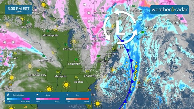
Weather & Radar
Home / Weather News /

One storm exits, another one on the move

12:10 PM
March 6, 2025

Breakfast Brief
One storm exits, another one on the move

While one system exits the U.S., some impacts will still be experienced across the Great Lakes and Northeast, and another system brings active weather to the Rockies. The Breakfast Brief is published daily, Monday through Friday, at 5:00 a.m. Eastern time.

A few morning snow showers will impact eastern Tennessee early Thursday, which could affect the morning commute. These snow showers will continue through the early afternoon across the Blue Ridge Mountains, the northern portion of the Appalachians, and Upstate New York. Liquid scattered precipitation will make its last rounds over New England, including Boston, around mid-afternoon.

The system that spun severe weather this week finally exits the U.S.

Strong gusts, sometimes reaching 45 mph, will occur in North Carolina and eastern South Carolina. The air will be cool and dry, which could enhance fire weather conditions across the region. Avoid activities that involve fires or sparks, as ignited fires could spread quickly.

The wind will be strong across the Florida Peninsula, and even though the weather will be beautiful and stable, marine hazards will be plentiful as the seas could be high. Winds could exceed 25 knots, especially along the Atlantic Coast, but they are still dangerous over the Gulf Coast.

Over the western half of the United States, the weather setup is more active, with an extensive low-pressure system centered over the Great Basin affecting over 1,000 miles from the Sierra Nevada to Denver. The heavy snowfall will taper off gradually late on Thursday across the Sierra but pick up across the Rockies as it migrates east. Phoenix will also see rains associated with this system in the morning hours. Southern California will get a few showers in the morning, a break, and the chance for heavier showers in the afternoon and evening.

News we're covering

  • Wildfires risk increases.
  • Heavy snow to impact the Rockies.
  • Strong winds continue over the Great Lakes and the East.

Things you might have missed

Powerful winds clocked in Texasread more
Iowans wake up to blizzardread more

App news & updates:

You might be planning your lunch or dinner activities. Take the 90-minute weather update for the most details, and be safe. Find out how here.

Mary Mays
More on the topic
Saturday, May 3, 2025

May astronomy outlook

Meteor shower and the Flower Moon
Man sits with telescope looking up at the Milky Way.
Tuesday, April 1, 2025

April astronomy outlook

A micromoon & the oldest known meteors
Saturday, April 19, 2025

Your weather - Your shots

Sunrise views and misty mornings
All weather news
This might also interest you
Wednesday, May 7, 2025

Rain piling up

Growing flood threat for New Orleans
Thursday, May 8, 2025

What season is it?

Great Lakes spring chill
Thursday, May 8, 2025

Breakfast Brief

Stormy southeast, tranquil West Coast
All articles
Weather & Radar

www.weatherandradar.com

instagramfacebookthreadsContact uslinkList
Privacy policy | Legal info