Home
Weather New York
WeatherRadar
RainRadar
TemperatureRadar
WindRadar
LightningRadar
Weather News
Editor's Pick
Discover the app
Weather widget
Contact us
Apps
Career
    Home / Weather News /

    Pacific Northwest Weather Shift: Cooler, Wetter Days Ahead This Week

04:03 PM
April 24, 2024

Rain & Snow Ahead
Cool Shift: PNW's Wet Weather

storm system arrives
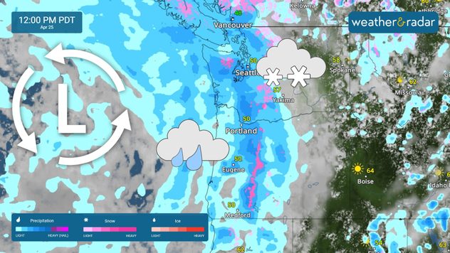
A stronger storm system is set to arrive on Thursday, bringing rain and mountain snow. See current conditions on the WeatherRadar.

The Pacific Northwest is headed for a shift in the weather pattern that will bring cooler, wetter conditions through the end of the month.

From Wednesday to Saturday, anticipate cooler, wetter weather as high pressure shifts east and a series of Pacific fronts make their way inland. Coastal areas may experience some drizzle by Wednesday morning, with the onset of rain likely in inland areas by Wednesday night into Thursday.

By Thursday night, a more robust storm system is set to hit the coast, potentially bringing snow to the Cascade passes and ushering in a period of unsettled weather. Expected rain totals through Saturday range from 0.50 to 1 inch in the lowlands, with up to 2 inches possible in the mountain areas.

As colder air moves in behind this system, snow levels are projected to drop to 3,000-4,000 feet at the passes by early Friday, and higher elevations could see several inches of snow. Cooler temperatures and rain showers will prevail across the lowlands, accompanied by a slight chance of thunderstorms.

Did you know?

Seattle typically experiences around 18 rainy days in April, accumulating nearly 2.71 inches of rainfall, making it one of the wettest spring months in the Pacific Northwest.

In lower elevation metro areas like Portland, Ore., and Seattle, Wash., temperatures are likely to remain in the 50s, with the likelihood of temperatures exceeding 60°F diminishing by Thursday. Classic Pacific Northwest weather is upon us—time to swap your sunglasses for raincoats!

Federico Di Catarina
More on the topic
All about nocturnal severe weather. Risks & preparedness. . . Saturday, August 22, 2026
Saturday, August 22, 2026

Risks & preparedness

All about nocturnal severe weather
Waterspouts possible, what are they?. They can be dangerous. . . Sunday, August 9, 2026
Waterspouts weatherradar.
Sunday, August 9, 2026

They can be dangerous

Waterspouts possible, what are they?
The best views of Wednesday's eclipse. Europe's sky show. . . Thursday, August 13, 2026
Solar eclipse: The sun obscured between wind turbines in Sardinia
Thursday, August 13, 2026

Europe's sky show

The best views of Wednesday's eclipse
All weather news
This might also interest you
Rockies cooling off. Seeking a taste of autumn. . . Saturday, September 12, 2026
Saturday, September 12, 2026

Seeking a taste of autumn

Rockies cooling off
Peak season but no activity. Atlantic Basin. . . Thursday, September 10, 2026
A quiet Atlantic at the peak of Atlantic Hurricane Season.
Thursday, September 10, 2026

Atlantic Basin

Peak season but no activity
Southwest turns hot, again!. New round of extreme heat. . . Wednesday, September 9, 2026
Hot weather across the Southwest.
Wednesday, September 9, 2026

New round of extreme heat

Southwest turns hot, again!
All articles
Weather & Radar

Weather & Radar is also available on

Google Play StoreApp Store

Company

Contact us Privacy policy Legal info Accessibility statement

Services

Uploader

Socials

instagramfacebookthreadslinkList