Weather & Radar
Home / Weather News /

Rainy, windy East, another West storm

09:00 AM
March 20, 2025

Breakfast brief
Rainy, windy East, another West storm

The low-pressure system that produced stormy weather across the southern Great Lakes moves east and brings strong winds to the Northeast and even parts of the Southeast, where the seas will become dangerous for popular Spring Break destinations. The Breakfast Brief is published daily, Monday through Friday, at 5:00 a.m. Eastern time.

Expect the storm to arrive in the Northeast by noon and continue to bring rounds of heavy rain and even a few scattered storms across the Mid-Atlantic on Thursday afternoon. New York City will experience downpours by late afternoon into the evening, with winds increasing as well. Boston's skies will remain cloudy most of the day as a large low-pressure system spinning offshore will provide much moisture all day.

Heavy rains to impact parts of the Northeast on Thursday.

The difference between these two pressure systems will squeeze the pressure gradient and increase the winds across much of the East. Gusts could exceed 45 mph along the Appalachians by the afternoon. As the cold front pushes through the Southeast, taking a few showers with it, the winds will become stronger along the Gulf Coast and the East Coast. Seas will be rough for both coasts of Florida, and there will be a high risk for rip currents, too. Spring Breakers are warned.

For the western half?

A smaller-scale low-pressure system entering the Northwest will move through the northern Plains on Thursday, producing snow showers across the Northern Rockies and mixed precipitation over the High Plains. Meanwhile, another system with much more moisture will slam against the Pacific Northwest and bring plenty of rains that will become more intense in the late afternoon and evening.

Rains are expected to continue through the end of this week and likely into the weekend for much of the Pacific Northwest. Rainfall totals through Saturday night could reach Up to 4 inches, and some isolated areas could exceed 6 inches, developing flooding.

The news we are covering

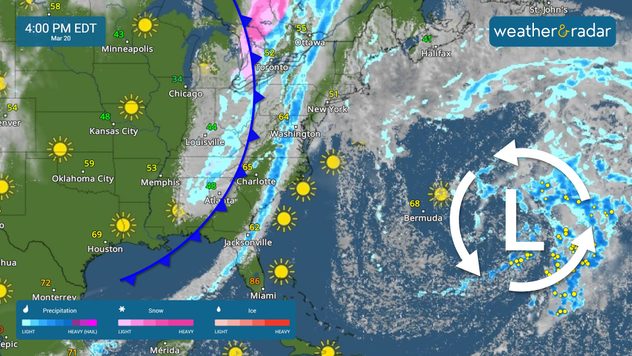
  • Rainy stretch for the Pacific Northwest
  • Windy East Coast
  • Rain for the Northeast & storms for the Mid-Atlantic

Things you may have missed

Blizzard conditions in Iowaread more

App News

Thank you for downloading us and keeping us close. Here, you will be able to find all the important features and explanations of the great tools our app offers, interesting weather features, and safety weather tips!

Irene Sans
More on the topic
Sleeping cat
Sunday, April 20, 2025

Seasonal tiredness

What causes spring fatigue?
Saturday, March 29, 2025

As Spring continues

UV forecasts in the app
Man sits with telescope looking up at the Milky Way.
Tuesday, April 1, 2025

April astronomy outlook

A micromoon & the oldest known meteors
All weather news
This might also interest you
Monday, May 5, 2025

Dusty twisters

Dust devils: not exactly a tornado
Monday, May 5, 2025

You can be ready

When severe storms strike...
Tuesday, May 6, 2025

Breakfast Brief

Blocking pattern brings dangerous rain
All articles
Weather & Radar

www.weatherandradar.com

instagramfacebookthreadsContact uslinkList
Privacy policy | Legal info