Weather & Radar
Home / Weather News /

Southeast is high & dry, mountain snow

10:00 AM
March 7, 2025

Breakfast Brief
Southeast is high & dry, mountain snow

The gigantic low-pressure system is still not completely done across the Northeast, and the Rockies are dealing with snow due to a low-pressure system that will try to let go, but another low is left behind for a bit longer. The Breakfast Brief is published daily, Monday through Friday, at 5:00 a.m. Eastern time.

The enormous storm that wreaked havoc across the Plains is finally making its final way out. But first, there will still be plenty of winds, especially across the Northeast, where wind gusts could exceed 50 mph at times. Our WindRadar shows it will be windy most of the day, with the strongest gusts gradually decreasing over the weekend, but still windy at times.

Very strong wind gusts will impact the Northeast all day Friday.

A high-pressure system center over the Southeast will move east of Florida, and this displacement will shift the winds across the Sunshine State and the rest of the Southeast. Due to the winds from the south-southeast, there will be a warming trend for the weekend, which starts this afternoon after having a cold morning. There will still be breezy conditions across the Southeast, with Atlanta getting gusts up to 20 mph by the evening.

A smaller scale (compared to the one exiting the Northeast) storm will move over the Central Plains on Friday. It will bring rounds of snow from Nebraska through the southern portion of the Great Lakes. Chicago could expect a round of rain before sunrise, followed by periods of heavy snow that could last through the afternoon and taper off after 8 p.m.

There is a critical fire danger across west Texas and southern New Mexico. Winds in this region are strong and could gust above 50 mph, mainly from the west-southwest. Wind will be dry and warm, fueling and spreading any developing fires. Make sure to avoid burns or anything that can spark. Fires can quickly become erratic and uncontrollable.

The weather finally improves for Southern California, where showers and mountain snow have been constant the last few days. This has been much-needed rain, but they could use a break. Los Angeles temperatures are rising, reaching the low-60s Friday afternoon and up to the low-70s Sunday afternoon.

News we're covering

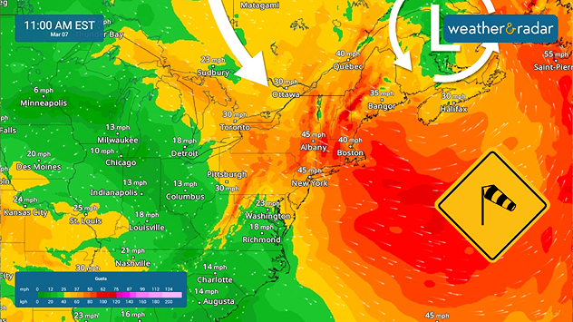
  • Wildfires risk increases for West Texas & New Mexico.
  • Snowy Chicago & surroundings.
  • Strong gusts for the Northeast.
  • Warming trend for Southeast.

Things you might have missed

Video: Wildfire near Gatlinburg, Tenn.read more
Much needed rainfall for SoCalread more

App news & updates:

The weekend is here. Take us with you anywhere you go and plan your activities correctly. Take the 90-minute weather update for the most details, and be safe. Find out how here.

Irene Sans
More on the topic
Man sits with telescope looking up at the Milky Way.
Tuesday, April 1, 2025

April astronomy outlook

A micromoon & the oldest known meteors
Saturday, May 3, 2025

May astronomy outlook

Meteor shower and the Flower Moon
easter
Sunday, April 20, 2025

A chance to reflect

Happy Easter to all
All weather news
This might also interest you
Monday, May 5, 2025

Dusty twisters

Dust devils: not exactly a tornado
Severe storms target eastern Texas with a tornado threat included.
Tuesday, May 6, 2025

LIVE storm chase

Severe threat continues in Texas, NE
Thursday, May 8, 2025

What season is it?

Great Lakes spring chill
All articles
Weather & Radar

www.weatherandradar.com

instagramfacebookthreadsContact uslinkList
Privacy policy | Legal info