Home
Weather New York
WeatherRadar
RainRadar
TemperatureRadar
WindRadar
LightningRadar
Weather News
Editor's Pick
Discover the app
Weather widget
Contact us
Apps
Career
    Home / Weather News /

    Stormy southeast, tranquil West Coast

08:00 AM
May 8, 2025

Breakfast Brief
Stormy southeast, tranquil West Coast

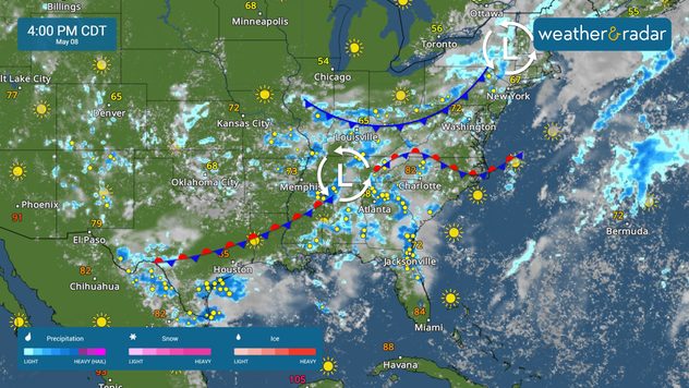
Scattered showers and storms will impact the southern Plains and the Southeast today, with a few strong storms possible. The West Coast remains tranquil. The Breakfast Brief is published Monday through Friday at 5:00 a.m. Eastern Time.

Scattered showers and thunderstorms are forecast today across the southern Plains and into the Southeast. Lingering rain will also impact the Northeast. While the eastern half of the country remains socked in with rain, the western half will be mostly tranquil.

Storms fire up along a boundary across the South.

The WeatherRadar shows storms firing up in Texas and across the Mid-South and Southeast. Strong storms are possible in cities like Laredo and Brownsville, Texas, Knoxville, Tenn., and Charlotte, N.C.

While heavy rain has significantly improved drought conditions east of the Mississippi River, flash flooding remains a concern in cities like New Orleans and Scranton, Penn., today.

Above-average warmth continues across much of the West Coast and the northern Plains, with cities like Bismarck, N.D., seeing temperatures up to 20 degrees warmer than average. The East Coast also sees warmer-than-average temperatures, with cooler-than-average air stretching from Texas to the Great Lakes.

News we're covering today

  • Stormy Southeast
  • Flooding threat continues

Things you may have missed

New Orleans flood threatread more
Learn about dust devilsread more

App news

When severe weather is in your forecast, you can be prepared. Follow along with these tools to stay weather-aware.

Mary Mays
More on the topic
The best views of Wednesday's eclipse. Europe's sky show. . . Thursday, August 13, 2026
Solar eclipse: The sun obscured between wind turbines in Sardinia
Thursday, August 13, 2026

Europe's sky show

The best views of Wednesday's eclipse
Meteorological vs astronomical autumn. Season start date. . . Tuesday, September 1, 2026
Tuesday, September 1, 2026

Season start date

Meteorological vs astronomical autumn
What are weather fronts?. Weather explained. . . Sunday, August 23, 2026
Image of a temperature radar showing a clear distinction between a warm and cold air mass separated by a cold front.
Sunday, August 23, 2026

Weather explained

What are weather fronts?
All weather news
This might also interest you
Northwest chilly showers. Autumn premiere. . . Thursday, September 3, 2026
A cooler Northwest
Thursday, September 3, 2026

Autumn premiere

Northwest chilly showers
What is it, and why is it important?. North American Monsoon. . . Sunday, September 6, 2026
Desert thunderstorm
Sunday, September 6, 2026

North American Monsoon

What is it, and why is it important?
9 inches of rain, 4 feet of surge. Texas & Louisiana. . . Tuesday, September 1, 2026
Tropical Storm Edouard will bring heavy rains and gusty winds, with flooding possible.
Tuesday, September 1, 2026

Texas & Louisiana

9 inches of rain, 4 feet of surge
All articles
Weather & Radar

Weather & Radar is also available on

Google Play StoreApp Store

Company

Contact us Privacy policy Legal info Accessibility statement

Services

Uploader

Socials

instagramfacebookthreadslinkList