Home
Weather New York
WeatherRadar
RainRadar
TemperatureRadar
WindRadar
LightningRadar
Weather News
Editor's Pick
Discover the app
Weather widget
Contact us
Apps
Career
    Home / Weather News /

    Summer preview concludes - Big Weekend cooldown

07:19 PM
April 16, 2026

Summer preview concludes
Big Weekend cooldown

The East and South might be baking under an early summer-like heat wave, but colder weather will spread across the U.S. this weekend.

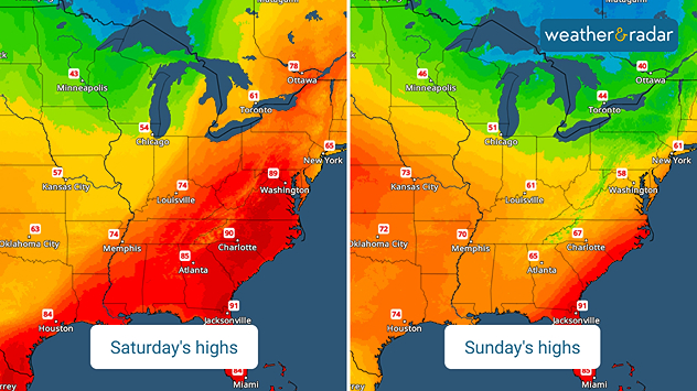
The TemperatureRadar is showing most places east of the Rockies in the 80s with a few 90s in the Mid-Atlantic today. These hot temperatures are interacting with a slow-moving storm system to produce more severe storms across the Northeast and part of the Midwest and the Ohio Valley.

This is just a small preview of the big changes ahead. A storm system moving out of western Canada will drag a potent cold front across the Plains late Friday and Saturday before moving into the East and South on Sunday.

The WeatherRadar shows this system producing heavy rain and thunderstorms along its path. In the wake, a significantly colder air mass will settle southward across the U.S. Afternoon highs on Saturday will only be in the 50s and 60s across the southern Plains, while Minneapolis will be in the 40s and Chicago will barely hit 50s.

Minneapolis

Th
75
92
Fr
76
94
Sa
73
90
Su
72
91
Mo
75
95
Tu
73
87
We
69
84
Th
70
88
Fr
68
83
Sa
64
82
Su
63
86
Mo
67
87
Tu
67
87
We
69
87
Max (°F)
Min (°F)
moreless

By Sunday, the East and South will only be in the 50s and 60s. This is in stark contrast to the 80s and 90s expected today.

James West
More on the topic
High pressure & extreme heat. Why & how does it work?. . . Sunday, July 12, 2026
Sunday, July 12, 2026

Why & how does it work?

High pressure & extreme heat
Super Typhoon Bavi threatens Taiwan. 155 mph winds. . Weather Videos. Wednesday, July 8, 2026
The image shows an intense tropical cyclone over the western Pacific, east of Taiwan and the Philippines. The centre of the system is depicted as a light purple and white vortex with a clearly visible eye, surrounded by a ring of red and orange areas indicating the strongest wind speeds. A white arrow marks the typhoon’s predicted track towards the north-west, in the direction of Taiwan. To the west of the storm lie the Philippines, with the cities of Manila and Cebu; to the north of these lies Taiwan, with Taipei. Further west, the Chinese coast, including Hong Kong, and parts of Vietnam can be seen. The coloured wind map shows predominantly green areas outside the storm’s core, indicating significantly weaker winds. White streamlines illustrate the typhoon’s anti-clockwise circulation in the Northern Hemisphere. The highest wind speeds are concentrated around the eye of the cyclone.
Weather VideosWednesday, July 8, 2026

155 mph winds

Super Typhoon Bavi threatens Taiwan
Super Typhoon Near the Philippines. Gusts up to 155. . . Tuesday, June 23, 2026
Tuesday, June 23, 2026

Gusts up to 155

Super Typhoon Near the Philippines
All weather news
This might also interest you
SW Texas quadruples its normal July rain. 7 inches and counting. . . Tuesday, July 14, 2026
Tuesday, July 14, 2026

7 inches and counting

SW Texas quadruples its normal July rain
Northern New England storms. Rare severe threat. . . Tuesday, July 14, 2026
Tuesday, July 14, 2026

Rare severe threat

Northern New England storms
Area to watch this weekend. Tropical trouble?. . . Wednesday, July 15, 2026
An area of low pressure is expected to develop this weekend off Florida's Big Bend. The question is: will this mean tropical trouble for the Southeast?
Wednesday, July 15, 2026

Tropical trouble?

Area to watch this weekend
All articles
Weather & Radar

Weather & Radar is also available on

Google Play StoreApp Store

Company

Contact us Privacy policy Legal info Accessibility statement

Services

Uploader

Socials

instagramfacebookthreadslinkList