Home
Weather New York
WeatherRadar
RainRadar
TemperatureRadar
WindRadar
LightningRadar
Weather News
Editor's Pick
Discover the app
Weather widget
Contact us
Apps
Career
    Home / Weather News /

    Texas severe threat, heat moves east

09:00 AM
March 28, 2025

Breakfast brief
Gulf Coast flood threat, wet PNW

Showers and storms will continue across south Texas and push along the northern Gulf Coast today. The Pacific Northwest remains active with coastal rain, mountain snow and gusty winds. The Breakfast Brief is published daily, Monday through Friday, at 5:00 a.m. Eastern time.

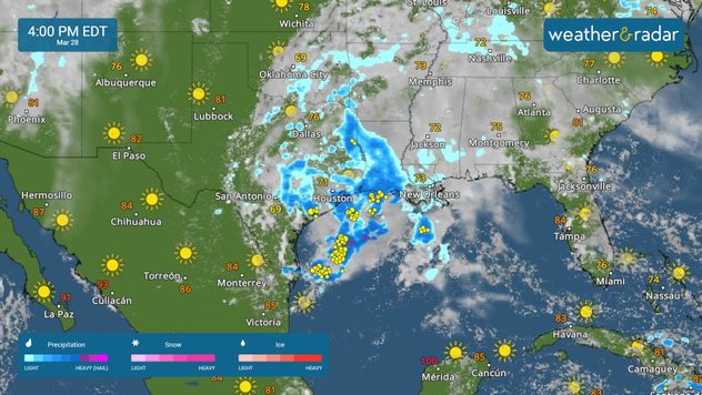
The WeatherRadar shows an active pattern from Texas to the northern Gulf Coast today. A few strong storms may impact the Texas and Louisiana coastlines. Gusty winds, hail and even an isolated tornado are possible.

Strong storms and flash flooding possible along the Gulf Coast.

Heavy rain will lash the coast in the Pacific Northwest, with dreary conditions from northern California to Seattle. Wet snow will fall in the high elevations of the Cascades and Sierra Nevada. Mixed rain and snow will also spread across Idaho and into the northern Rockies.

Above-average temperatures move east, with record highs possible across parts of the central Plains and Midwest. Rain-cooled air keeps temperatures below average for the West Coast.

The news we are covering

  • Strong storms and flash flooding possible for Gulf Coast.
  • Rain and snow for the Pacific Northwest

Things you may have missed

History made in the PNWread more
Learn more about the RainRadarread more

App News

Thank you for downloading and keeping us close. Here, you will find all the important features and explanations of our app's great tools, interesting weather features, and safety weather tips!

Mary Mays
More on the topic
Super Typhoon Bavi threatens Taiwan. 155 mph winds. . Weather Videos. Wednesday, July 8, 2026
The image shows an intense tropical cyclone over the western Pacific, east of Taiwan and the Philippines. The centre of the system is depicted as a light purple and white vortex with a clearly visible eye, surrounded by a ring of red and orange areas indicating the strongest wind speeds. A white arrow marks the typhoon’s predicted track towards the north-west, in the direction of Taiwan. To the west of the storm lie the Philippines, with the cities of Manila and Cebu; to the north of these lies Taiwan, with Taipei. Further west, the Chinese coast, including Hong Kong, and parts of Vietnam can be seen. The coloured wind map shows predominantly green areas outside the storm’s core, indicating significantly weaker winds. White streamlines illustrate the typhoon’s anti-clockwise circulation in the Northern Hemisphere. The highest wind speeds are concentrated around the eye of the cyclone.
Weather VideosWednesday, July 8, 2026

155 mph winds

Super Typhoon Bavi threatens Taiwan
Europe: Warmest June on record. Warm waters too. . . Friday, July 10, 2026
The record-breaking heatwave in June has made climate history in Western Europe.
Friday, July 10, 2026

Warm waters too

Europe: Warmest June on record
Super Typhoon Near the Philippines. Gusts up to 155. . . Tuesday, June 23, 2026
Tuesday, June 23, 2026

Gusts up to 155

Super Typhoon Near the Philippines
All weather news
This might also interest you
Desert Southwest heat for the Dakotas. 1,000-mile difference. . . Monday, July 13, 2026
Monday, July 13, 2026

1,000-mile difference

Desert Southwest heat for the Dakotas
SW Texas quadruples its normal July rain. 7 inches and counting. . . Tuesday, July 14, 2026
Tuesday, July 14, 2026

7 inches and counting

SW Texas quadruples its normal July rain
Follow the clouds. High-pressure ridge. . . Monday, July 13, 2026
Monday, July 13, 2026

High-pressure ridge

Follow the clouds
All articles
Weather & Radar

Weather & Radar is also available on

Google Play StoreApp Store

Company

Contact us Privacy policy Legal info Accessibility statement

Services

Uploader

Socials

instagramfacebookthreadslinkList