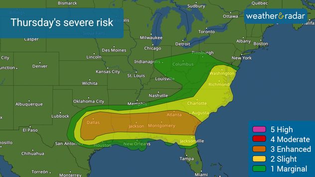
Home
Weather New York
WeatherRadar
RainRadar
TemperatureRadar
WindRadar
LightningRadar
Weather News
Editor's Pick
Discover the app
Weather widget
Contact us
Apps
Career
Home / Editor's Pick /

Thursday's live blog: Big cities targeted for severe storms

08:19 PM
May 9, 2024

Thursday's live blog
Big cities targeted for severe storms

Recommended external content from YouTube

We need your consent to show content from YouTube. You can withdraw your consent at any time.

I agree that content from YouTube will be displayed to me.

Settings for external content

Privacy policy

Thursday's live blog covers the potential for several tornadoes across the South and East. There is also the risk for damaging winds of at least 80 mph and large hail. Weather & Radar storm chasers will be streaming live from the field until the eveneing.

5 p.m. CT

Thursday's severe risk includes Dallas, Austin, through Atlanta. Thursday's severe risk includes Dallas, Austin through Atlanta.

The enhanced risk (level 3 out of 5) of severe thunderstorms spans from central Texas to southern Georgia and the central Gulf Coast states and will continue into the evening hours.

This blog is no longer being updated. Please refer to the WeatherRadar to track storms near you.

4:20 p.m. CT

Our storm chasers intercepted a severe warned thunderstorm producing large hail about 30 miles southwest of Dallas-Fort Worth.

The likelihood of very large hail with multiple supercells is high across north and central Texas into the ArkLaTex area. Additionally, a wider region from east Texas to the lower Mississippi Valley and Southeast faces the potential for severe hail and damaging winds.

3 p.m. CT

Golf-sized hail is happening in the storms moving north of the Dallas-Fort Worth area. Tioga is getting golf-size hail that could damage vehicles and property. Take cover if you are in the area.

Safety tip during severe weather

Remember, an overpass is not a safe shelter during severe weather! Never stop under an overpass to protect yourself. Keep driving and find a secure location to pull off the road. Seek shelter in a strong, sturdy building instead.

2 p.m. CT

Strong storms are sweeping through portions of the Metroplex. A tornado watch is in effect until at least 9 p.m. CT for North Texas southward toward Waco and Lampasas.

11 a.m. CT

It was a devastating Wednesday evening across parts of north and western Tennesse, western Kentucky through the Ozarks. There were over 400 severe reports, including 14 tornado reports, and almost 400 reports of damaging winds and large hail.

Tuesday's impacts are part of a multi-day severe weather outbreak that is unleashing a series of destructive tornadoes and severe thunderstorms across the central U.S. Our meteorologist James West has a full recap including the images we received from our weather reporter and team of storm chasers.

Tornadoes, storms brought destructionread more

10 a.m. CT

Meteorologist Mary Mays will discuss the severe scenario laid out for Thursday live on our YouTube channel. Watch it live starting at noon Eastern time.

9 a.m. CT

A tornado watch is in effect for north and central Georgia, including for Atlanta until 1 p.m. for the northern parts and until 5 p.m. for the central region. Central Alabama is also under a tornado watch through the afternoon too. This means tornadoes are possible as weather conditions are favorable for them to develop.

8 a.m. CT

Another active day South, Eastread more

This makes the fourth day of severe weather this workweek, and the target is not the Southeast. An enhanced risk, level 3 out of 5 on the severity scale, covers the Metroplex in Texas through Savannah, Georgia, including big metro areas like Austin, Atlanta, and Birmingham, Missi. There could be a few separate rounds of storms affecting the same cities hours apart. Find the latest forecast written by meteorologist James West below.

Irene Sans
More on the topic
Saturday, February 21, 2026

Find the lotion!

Dry skin season is back
fog
Sunday, February 22, 2026

Safety tips: fog

Driving during foggy conditions
EF-2 tornado pictured in Colorado
Sunday, March 8, 2026

World of Twisters

Tornado myths answered
All weather news
This might also interest you
Monday, March 9, 2026

Through midweek

Record warmth for the Eastern half
Wednesday, March 4, 2026

Beginning Friday

Flood risk from Texas to Mississippi Valley
Saturday, March 7, 2026

What to know

The dangers of hail
All articles
Weather & Radar

Weather & Radar is also available on

Google Play StoreApp Store

Company

Contact us Privacy policy Legal info Accessibility statement

Services

Uploader

Socials

instagramfacebookthreadslinkList