Home
Weather New York
WeatherRadar
RainRadar
TemperatureRadar
WindRadar
LightningRadar
Weather News
Editor's Pick
Discover the app
Weather widget
Contact us
Apps
Career
    Home / Weather News /

    Tools you can use - First major winter storm of the year

07:57 PM
January 2, 2025

Tools you can use
First major winter storm of the year

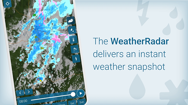
Forecasts are coming together and pointing to what is likely to be a major winter storm for the first weekend of 2025. Snow, ice, severe thunderstorms and isolated flooding are all expected. We have some tips on how you can monitor this evolving forecast on the Weather & Radar app.

The WeatherRadar is your main go-to when getting an idea of an incoming storm event. Rainfall (blue), frozen precipitation (orange), snow (pink), lightning (yellow dots), clouds (white) and the temperatures are all shown up to four days into the future. For this storm, you'll see all of these parameters in action as the storm begins to come together starting Saturday on the WeatherRadar.

1/6

A few things are coming together to help this system form. First, in the upper levels, a low-pressure trough carrying a cold blast and gusty winds will carry the wintry energy down from the northern tier to the central U.S. where it will meet up with a surface low-pressure. As it moves out of the Front Range to the central Plains, it pulls plentiful moisture out of the Gulf.

The combination of cold air, gusty winds and Gulf moisture will create this extensive storm system. The northern flank will drop heavy snow with heavy rain and even severe storms coming up on the southern flank. Ice chances are sandwiched in the middle, posing the risk of power outages.

While we're not touching on totals just yet for the ice or snow, there is a way to be best prepared so that when this information is available, you're the first to know. The app alerts are a great asset to have in your winter toolkit to know what is coming and when. You can easily switch these on in the app in the main menu.

Western Carolina snowfallread more

If you have weekend plans, be sure to check back here frequently for more information.

Becca Parker
More on the topic
Super Typhoon Bavi threatens Taiwan. 155 mph winds. . Weather Videos. Wednesday, July 8, 2026
The image shows an intense tropical cyclone over the western Pacific, east of Taiwan and the Philippines. The centre of the system is depicted as a light purple and white vortex with a clearly visible eye, surrounded by a ring of red and orange areas indicating the strongest wind speeds. A white arrow marks the typhoon’s predicted track towards the north-west, in the direction of Taiwan. To the west of the storm lie the Philippines, with the cities of Manila and Cebu; to the north of these lies Taiwan, with Taipei. Further west, the Chinese coast, including Hong Kong, and parts of Vietnam can be seen. The coloured wind map shows predominantly green areas outside the storm’s core, indicating significantly weaker winds. White streamlines illustrate the typhoon’s anti-clockwise circulation in the Northern Hemisphere. The highest wind speeds are concentrated around the eye of the cyclone.
Weather VideosWednesday, July 8, 2026

155 mph winds

Super Typhoon Bavi threatens Taiwan
How does fog form?. Multiple ways. . . Saturday, July 11, 2026
Saturday, July 11, 2026

Multiple ways

How does fog form?
Meteorological summer is here!. Bye, spring!. . . Monday, June 1, 2026
Monday, June 1, 2026

Bye, spring!

Meteorological summer is here!
All weather news
This might also interest you
Gulf system is becoming better organized. It moves slowly. . . Monday, July 20, 2026
Monday, July 20, 2026

It moves slowly

Gulf system is becoming better organized
Be prepared for wildfires. By using the app. . . Saturday, July 18, 2026
Wildfires can spark anywhere, anytime. The Weather & Radar app can help you determine your area's risk.
Saturday, July 18, 2026

By using the app

Be prepared for wildfires
Up to four feet of storm surge. Gulf Coast soaker. . . Tuesday, July 21, 2026
Tropical storm alerts are active in the app as Bertha continues to churn in the northern Gulf.
Tuesday, July 21, 2026

Gulf Coast soaker

Up to four feet of storm surge
All articles
Weather & Radar

Weather & Radar is also available on

Google Play StoreApp Store

Company

Contact us Privacy policy Legal info Accessibility statement

Services

Uploader

Socials

instagramfacebookthreadslinkList