Home
Weather New York
WeatherRadar
RainRadar
TemperatureRadar
WindRadar
LightningRadar
Weather News
Editor's Pick
Discover the app
Weather widget
Contact us
Apps
Career
    Home / Editor's Pick /

    Tropical update: Franklin turns north to Hispaniola

06:17 PM
August 22, 2023

Tropical update
Franklin turns north to Hispaniola

As we continue to watch how Harold moves inland over south Texas and northeastern Mexico, the Atlantic Basin continues to be on fire! The next landfalling system is Franklin, heading to the Dominican Republic early on Wednesday. Let´s discuss.

Franklin is a huge rainmaker

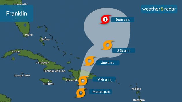
Franklin has made its northward turn, and it is about 200 mph miles south-southwest of Santo Domingo, Dominican Republic. Franklin is forecast to intensify a bit during the rest of the day on Tuesday, likely reaching 60 mph. Now that the system has made the turn north, it will start to gain speed, as it comes closer to a likely landfalling spot in Barahona, Dominican Republic. Between 2 to 4 inches of rain are possible, but some areas can get up to 6 in Puerto Rico. While in the DR and Haiti, up to 15 inches of rain can accumulate and generally between 5 and 10 inches are possible. Landslides are possible. Flash floods are also a big concern.

Franklin's track issued on Tuesday late morning.

Winds will be strong along the southern coast of the Dominican Republic and Haiti, but the strongest gusts will come to the area east wherever the center makes landfall. The system will be traveling over the highest Caribbean mountains on Wednesday in the Dominican Republic and emerge over the Atlantic and bring tropical storm-force winds to the Turk and Caicos Islands

Gert is history!

Tropical Storm Gert become a post-tropical cyclone and it is expected to remain weak as it stays stationary to the northeast of the Caribbean.

What used to be Emily, is now a tropical wave

Emily could revive later this week, but luckily over the subtropical Atlantic and it does not pose a threat to land.

Terminology you should knowread more

Far eastern tropical wave

It does not seem like this one will be a worry to land either. Following Emily´s footsteps it will remain over the Central Atlantic.

**This same information can be seen in Spanish, written by our bilingual meteorologists if your phone is set to Spanish and using our app too. Tell your family and friends that only speak Spanish so that they can also be informed and stay safe, please.**

Irene Sans
More on the topic
Rip currents & safety tips. As more head to the coast. . . Saturday, July 25, 2026
rip current
Saturday, July 25, 2026

As more head to the coast

Rip currents & safety tips
Longest day of the year is here. Summer solstice. . . Sunday, June 21, 2026
Sunday, June 21, 2026

Summer solstice

Longest day of the year is here
Meteorological summer is here!. Bye, spring!. . . Monday, June 1, 2026
Monday, June 1, 2026

Bye, spring!

Meteorological summer is here!
All weather news
This might also interest you
Lopsided Bertha moves west. Who sees the impacts. . . Thursday, July 23, 2026
Thursday, July 23, 2026

Who sees the impacts

Lopsided Bertha moves west
Southwest heat disrupts daily flow. Closures & delays. . . Monday, July 27, 2026
Monday, July 27, 2026

Closures & delays

Southwest heat disrupts daily flow
Multi-day rain event ends soon. Southeast U.S.. . . Friday, July 24, 2026
Friday, July 24, 2026

Southeast U.S.

Multi-day rain event ends soon
All articles
Weather & Radar

Weather & Radar is also available on

Google Play StoreApp Store

Company

Contact us Privacy policy Legal info Accessibility statement

Services

Uploader

Socials

instagramfacebookthreadslinkList