Home
Weather New York
WeatherRadar
RainRadar
TemperatureRadar
WindRadar
LightningRadar
Weather News
Editor's Pick
Discover the app
Weather widget
Contact us
Apps
Career
    Home / Editor's Pick /

    Tropical update: High flood risk for central Caribbean

04:31 PM
November 17, 2023

Tropical update
High flood risk for central Caribbean

Hurricane Hunters determined that the broad area of low pressure over the western Caribbean had a better-defined center of circulation and, due to its proximity to land, the National Hurricane Center classified it as Potential Tropical Cyclone 22. There is a chance for this system to become a named system on Friday as it comes closer to the central Caribbean islands.

The system is moving slowly away from Central America, but it is so broad that the heavy showers will still affect Panama and Costa Rica.
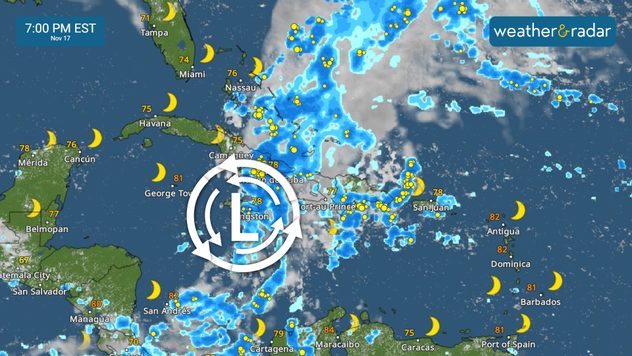
Most active period for the Greater Antilles will be from Friday to Saturday. High flood risk in place.

The storm does not have much time to become a tropical storm, as it will likely merge with a trough in the mid-levels of the atmosphere on Sunday as it passes around the southern Bahamas. Soon, the system will become an extratropical storm on Sunday.

The system on Friday morning remains disorganized as it slowly moves to the northeast at about 10 mph. It holds maximum sustained winds of 30 mph, so it is just below tropical storm status. Regardless of whether the system officially received a name or not, the outcome will be the same - torrential rains for Jamaica, southern Cuba, Haiti, the Dominican Republic, Turk and Caicos, and the southern region of the Bahamas.

What is a Potential Tropical Cyclone?

It is the classification given to a system that is not fully developed, but is expected to be, and is close to land. Due to its proximity and with this classification, watches and warnings can be issued to keep the public alert.

Central Caribbean impacts

As we have discussed all week, every morning, the periods of heavy rains have moved onto Jamaica, southern Cuba, and Haiti overnight into Friday morning. The most active day for this region will be today into Saturday as the system comes closer, increasing the heavy rain activity which will likely develop floods and could also form mudslides and landslides over the high terrains. The Dominican Republic will also notice a sharp increase in rain showers later Friday and Saturday. Periods of heavy rains will be affecting the central region of the Caribbean, including the southern Bahamas through Monday morning.

Rainfall across the mentioned areas could exceed 16 inches. Overall, between 5 to 10 inches of rain are possible. Minor flooding due to storm surge across the southeastern Bahamas and Turk and Caicos (these islands are flatter in nature). High surf will affect the central Caribbean along with a high risk for rip currents. Please remain out of the water, this will not be a weekend for marine activities.

We will be monitoring the evolution of this system and will continue to provide you with updates.

**You can find this same information in Spanish (also written by our bilingual meteorologists) in our app, just by setting the language to Spanish in the app settings.

Irene Sans
More on the topic
Record-breaking heatwave in Europe. Hotter than most of U.S.. . . Thursday, June 25, 2026
Thursday, June 25, 2026

Hotter than most of U.S.

Record-breaking heatwave in Europe
How does fog form?. Multiple ways. . . Saturday, July 11, 2026
Saturday, July 11, 2026

Multiple ways

How does fog form?
High pressure & extreme heat. Why & how does it work?. . . Sunday, July 12, 2026
Sunday, July 12, 2026

Why & how does it work?

High pressure & extreme heat
All weather news
This might also interest you
Up to four feet of storm surge. Gulf Coast soaker. . . Tuesday, July 21, 2026
Tropical storm alerts are active in the app as Bertha continues to churn in the northern Gulf.
Tuesday, July 21, 2026

Gulf Coast soaker

Up to four feet of storm surge
Lopsided Bertha moves west. Who sees the impacts. . . Thursday, July 23, 2026
Thursday, July 23, 2026

Who sees the impacts

Lopsided Bertha moves west
Multi-Day flood threat for Mid-Atlantic. Stalled front. . . Wednesday, July 22, 2026
Wednesday, July 22, 2026

Stalled front

Multi-Day flood threat for Mid-Atlantic
All articles
Weather & Radar

Weather & Radar is also available on

Google Play StoreApp Store

Company

Contact us Privacy policy Legal info Accessibility statement

Services

Uploader

Socials

instagramfacebookthreadslinkList