Home
Weather New York
WeatherRadar
RainRadar
TemperatureRadar
WindRadar
LightningRadar
Weather News
Editor's Pick
Discover the app
Weather widget
Contact us
Apps
Career
    Home / Weather News /

    Tuesday's live blog: Severe storms and flooding target Texas

09:31 PM
May 28, 2024

Tuesday's live blog
Severe storms and flooding target Texas

Powerful storms are targeting the Lone Star State, with dangerous storms rolling across western Texas. Track them .

5 p.m. CDT

As our WeatherRadar shows storms continue to fire across western Texas. These will continue through the tonight.

4:15 p.m. CDT

It has been a wild day across Texas as storms hit Dallas earlier and hitting Houston within past several hours.

This was from earlier in Dallas:

While, in Houston, power was flickering in a newsroom when storms arrived:

4:00 p.m. CDT

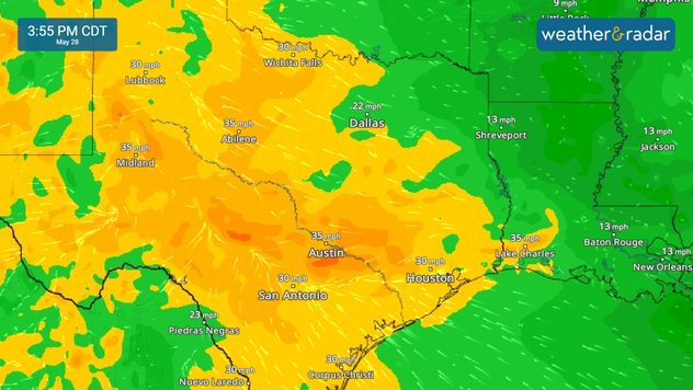
Gusty winds across portions of Texas and Louisiana will continue, both in and outside of thunderstorms. Keep an eye on gusts with our WindRadar.

WindRadar

3:00 p.m. CDT

The WeatherRadar shows heavy downpours slamming the Texas and Louisiana coastlines. More than one million customers are without power in Texas, with 20,000 without power now in Louisiana.

2:00 p.m. CDT

Power outages continue to impact Texas. More than 962,000 customers are without power across the Lone Star State as of this update.

1:00 p.m. CDT

Parts of central Texas have been removed from the enhanced risk, however, there is still the threat of strong storms and flash flooding in this area. Stay alert!

12:00 p.m. CDT

Storms capable of producing damaging winds will move into parts of Louisiana over the next few hours. Strong storms continue to impact parts of eastern Texas.

11:00 a.m. CDT

Outflow boundaries will have a significant impact on where storms develop later this morning and into the afternoon. Keep an eye on the WeatherRadar for the latest.

10:15 a.m. CDT

Flooding is also a significant concern today. A moderate risk, a level 3 out of 4, of excessive rain is in place across central Texas today. Remember to turn around, don't drown, if you come across water on the road.

9:30 a.m. CDT

Nearly 800,000 customers are without power this morning in northeast Texas as strong storms work through the region. Keep an eye on the WeatherRadar today. Much of Texas is under an enhanced risk, a level 3 out of 5, of severe storms today.

More on the topic
Rip currents & safety tips. As more head to the coast. . . Sunday, July 5, 2026
rip current
Sunday, July 5, 2026

As more head to the coast

Rip currents & safety tips
Longest day of the year is here. Summer solstice. . . Sunday, June 21, 2026
Sunday, June 21, 2026

Summer solstice

Longest day of the year is here
Meteorological summer is here!. Bye, spring!. . . Monday, June 1, 2026
Monday, June 1, 2026

Bye, spring!

Meteorological summer is here!
All weather news
This might also interest you
How does a hurricane form?. Hurricane preparedness. . . Sunday, July 19, 2026
hurricane maria
Sunday, July 19, 2026

Hurricane preparedness

How does a hurricane form?
Year's worth of rainfall piling up. Southwest Texas. . . Thursday, July 16, 2026
Extreme weather alerts active in Southwest Texas.
Thursday, July 16, 2026

Southwest Texas

Year's worth of rainfall piling up
Area to watch this weekend. Tropical trouble?. . . Wednesday, July 15, 2026
An area of low pressure is expected to develop this weekend off Florida's Big Bend. The question is: will this mean tropical trouble for the Southeast?
Wednesday, July 15, 2026

Tropical trouble?

Area to watch this weekend
All articles
Weather & Radar

Weather & Radar is also available on

Google Play StoreApp Store

Company

Contact us Privacy policy Legal info Accessibility statement

Services

Uploader

Socials

instagramfacebookthreadslinkList