Home
Weather New York
WeatherRadar
RainRadar
TemperatureRadar
WindRadar
LightningRadar
Weather News
Editor's Pick
Discover the app
Weather widget
Contact us
Apps
Career
    Home / Weather News /

    Wednesday's live blog - Meandering Debby brings flooding

01:18 PM
August 7, 2024

Wednesday's live blog
Meandering Debby brings flooding

Tropical Storm Debby is slowly meandering offshore of the Southeast and will continue to bring rain to Georgia and the Carolinas. We're keeping you up-to-date with this live blog.

Latest forecast analysisread more

5:00 p.m. ET

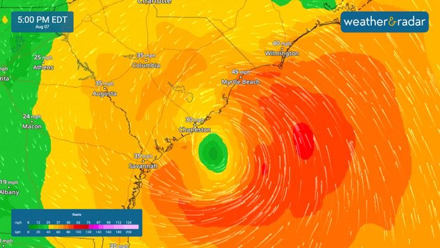
Tropical Storm Debby will make a second landfall in South Carolina by tomorrow. Winds are gusting to 45 mph in Myrtle Beach, S.C., with higher gusts possible tonight.

4:00 p.m. ET

Since Saturday, more than a foot of rain has fallen in parts of Florida, Georgia, and South Carolina. With more rain on the way, the flood threat will continue, especially in South Carolina and North Carolina.

2:30 p.m. ET

Debby's sustained winds have increased to 60 mph. Follow along on the WindRadar for the latest changes with this storm.

1:30 p.m. ET

Tornadoes cannot be ruled out in eastern North Carolina this afternoon as Debby's outer bands push onshore.

12:30 p.m. ET

As Debby's winds push water onshore, coastal flooding remains a concern. The South Carolina and North Carolina coastlines could see 1-3 feet of storm surge as Debby meanders off the coast.

11:30 a.m. ET

The most significant risk of flash flooding will push north into the weekend. Currently, the greatest threat of flooding remains over the Carolinas.

10:30 a.m. ET

Some strengthening of Debby is expected today into tomorrow morning as it sits over the warm water in the Atlantic. However, despite the expected strengthening, it's forecasted to stay a tropical storm.

9:45 a.m. ET

More than 10 inches of rain has fallen in parts of Georgia and South Carolina in the last 48 hours.

9:15 a.m. ET

Tropical Storm Debby is centered south-southeast of Charleston, South Carolina, with sustained winds of 45 mph and moving northeast at just 4 mph. This morning, Debby is producing scattered bands of rain from South Carolina to eastern North Carolina.

Mary Mays
This might also interest you
Waves of rain for the Midwest, Plains. Ocean-like pattern. . . Tuesday, September 15, 2026
Think of the atmosphere like an ocean, with waves constantly moving through it. This week, those waves will bring rounds of rain from the southern Rockies into the Plains, Midwest and Missouri Valley.
Tuesday, September 15, 2026

Ocean-like pattern

Waves of rain for the Midwest, Plains
1.2K miles of winds, rain & storms. Central & Southwest U.S.. . . Monday, September 14, 2026
Monday, September 14, 2026

Central & Southwest U.S.

1.2K miles of winds, rain & storms
Record ocean heat halting hurricanes. Strong El Niño influence. . . Sunday, September 13, 2026
A weather map shows a calm Atlantic Ocean with no hurricanes, alongside a picture of the sea.
Sunday, September 13, 2026

Strong El Niño influence

Record ocean heat halting hurricanes
All articles
Weather & Radar

Weather & Radar is also available on

Google Play StoreApp Store

Company

Contact us Privacy policy Legal info Accessibility statement

Services

Uploader

Socials

instagramfacebookthreadslinkList