Home
Weather New York
WeatherRadar
RainRadar
TemperatureRadar
WindRadar
LightningRadar
Weather News
Editor's Pick
Discover the app
Weather widget
Contact us
Apps
Career
    Home / Weather News /

    Wednesday's live blog: Severe threat stretchs from Texas to NY

03:32 PM
May 22, 2024

Wednesday's live blog
Severe threat stretchs from Texas to NY

More severe storms are expected on the heels of Tuesday's deadly tornado outbreak that impacted the Midwest. Damaging winds, tornadoes, large hail, and flash flooding threats extend from the Plains to the Great Lakes today. This live blog will have up-to-the-minute updates throughout the day.

Deadly twister flattens Greenfieldread more

4:00 p.m. CT

With intense storms developing in Texas, now is the time to turn on your Weather & Radar app alerts. Click the link below to learn how.

How to turn on your app alertsread more

3:00 p.m. CT

Severe storms are firing up from the Plains to the Northeast. A few tornadoes are possible in Texas.

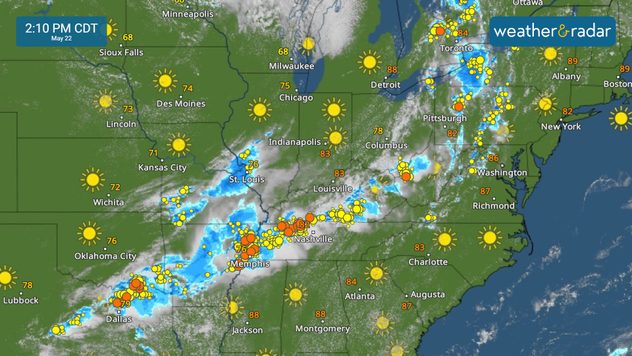
2:10 p.m. CT

Storms extend from Texas to New York on the WeatherRadar. Keep an eye on conditions in your area.

WeatherRadar

1:00 p.m. CT

A tornado watch is now in effect for parts of north and central Texas through 8 p.m. CT. Conditions are favorable for tornado development. Now is a good time to make sure your Weather & Radar app alerts are turned on.

12:00 p.m. CT

Flash flooding is also a concern today, with a slight risk (a level 2 out of 5) of excessive rain in effect across northern Texas, southern Oklahoma, and Arkansas.

11:00 a.m. CT

The WeatherRadar shows strong storms erupting across the central Plains and over the lower Great Lakes.

10:00 a.m. CT

Severe storms are once again a threat for millions today. The threat of strong storms extends from Texas to New York, with the greatest risk of severe weather stretching from central Texas into Arkansas.

More on the topic
10 facts about fog. Low clouds. . . Sunday, September 27, 2026
Fog impacting the Appalachian Mountains.
Sunday, September 27, 2026

Low clouds

10 facts about fog
Record ocean heat halting hurricanes. Strong El Niño influence. . . Sunday, September 13, 2026
A weather map shows a calm Atlantic Ocean with no hurricanes, alongside a picture of the sea.
Sunday, September 13, 2026

Strong El Niño influence

Record ocean heat halting hurricanes
Hawaii's second 2026 hurricane impact. Hurricane Lowell. . . Tuesday, September 8, 2026
Tuesday, September 8, 2026

Hurricane Lowell

Hawaii's second 2026 hurricane impact
All weather news
This might also interest you
Spring Tides: Flooding, Road Closures. Happening along coasts. . . Tuesday, September 29, 2026
Tuesday, September 29, 2026

Happening along coasts

Spring Tides: Flooding, Road Closures
Rounds of rain for Florida. Not so Sunshine State. . . Monday, October 5, 2026
While October typically marks a transition to drier weather in Florida, the first full week of the month is kicking off with heavy rain. But how much rain are we talking about?
Monday, October 5, 2026

Not so Sunshine State

Rounds of rain for Florida
Merging storms to bring record rain. Southwest, Plains. . . Tuesday, September 29, 2026
Heavy rainfall is expected across the Plains and Southwest, with flash flooding possible.
Tuesday, September 29, 2026

Southwest, Plains

Merging storms to bring record rain
All articles
Weather & Radar

Weather & Radar is also available on

Google Play StoreApp Store

Company

Contact us Privacy policy Legal info Accessibility statement

Services

Uploader

Socials

instagramfacebookthreadslinkList