Home
Weather New York
WeatherRadar
RainRadar
TemperatureRadar
WindRadar
LightningRadar
Weather News
Editor's Pick
Discover the app
Weather widget
Contact us
Apps
Career
    Home / Editor's Pick /

    An incredible sight, noctilucent clouds return

01:00 PM
June 16, 2024

Incredible sight
Noctilucent clouds return

Recommended external content from YouTube

We need your consent to show content from YouTube. You can withdraw your consent at any time.
I agree that content from YouTube will be displayed to me.
Privacy policy

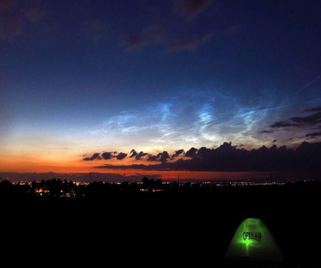
Incredible noctilucent clouds can now be seen above the northern horizon in the high latitudes.

With a little bit of luck, people at latitudes between 45 and 80 degrees north and south will be able to see stunning noctilucent clouds. These incredible clouds can be seen from mid-May until the end of July in the northern hemisphere.

Noctilucent clouds

How they form

Noctilucent clouds are made up of ice crystals. During the summer the mesosphere becomes cold enough to allow ice to form on suspended dust particles floating in the atmosphere. The dust particles may originate from micrometeorites falling to Earth from space, or the dust left over from volcanic eruptions.

These clouds form 47 to 53 miles above the Earth's surface, making them the world's highest clouds.

More on the topic
Waterspouts possible, what are they?. They can be dangerous. . . Sunday, August 9, 2026
Waterspouts weatherradar.
Sunday, August 9, 2026

They can be dangerous

Waterspouts possible, what are they?
All about nocturnal severe weather. Risks & preparedness. . . Saturday, August 22, 2026
Saturday, August 22, 2026

Risks & preparedness

All about nocturnal severe weather
Super Typhoon Bavi threatens Taiwan. 155 mph winds. . Weather Videos. Wednesday, July 8, 2026
The image shows an intense tropical cyclone over the western Pacific, east of Taiwan and the Philippines. The centre of the system is depicted as a light purple and white vortex with a clearly visible eye, surrounded by a ring of red and orange areas indicating the strongest wind speeds. A white arrow marks the typhoon’s predicted track towards the north-west, in the direction of Taiwan. To the west of the storm lie the Philippines, with the cities of Manila and Cebu; to the north of these lies Taiwan, with Taipei. Further west, the Chinese coast, including Hong Kong, and parts of Vietnam can be seen. The coloured wind map shows predominantly green areas outside the storm’s core, indicating significantly weaker winds. White streamlines illustrate the typhoon’s anti-clockwise circulation in the Northern Hemisphere. The highest wind speeds are concentrated around the eye of the cyclone.
Weather VideosWednesday, July 8, 2026

155 mph winds

Super Typhoon Bavi threatens Taiwan
All weather news
This might also interest you
Gravity wave clouds explained. The ideal conditions. . . Saturday, August 22, 2026
Saturday, August 22, 2026

The ideal conditions

Gravity wave clouds explained
What to know this hurricane season. Knowledge is power. . . Sunday, August 23, 2026
Hurricanes approaching the coastline can cause extensive impacts, including flooding, even before landfall.
Sunday, August 23, 2026

Knowledge is power

What to know this hurricane season
Tornado producer brings fall refresh. Northeast low. . . Friday, August 21, 2026
Friday, August 21, 2026

Northeast low

Tornado producer brings fall refresh
All articles
Weather & Radar

Weather & Radar is also available on

Google Play StoreApp Store

Company

Contact us Privacy policy Legal info Accessibility statement

Services

Uploader

Socials

instagramfacebookthreadslinkList