Home
Weather New York
WeatherRadar
RainRadar
TemperatureRadar
WindRadar
LightningRadar
Weather News
Editor's Pick
Discover the app
Weather widget
Contact us
Apps
Career
    Home / Editor's Pick /

    Breakfast Brief: Autumn feel spreads across East

12:18 PM
October 15, 2024

Breakfast Brief
Autumn feel spreads across East

Autumn is spreading across more of the U.S. today, with the Great Plains already waking up to some early morning frost and freezes. Summer remains locked in several spots, delaying the autumn's arrival.

A strong autumn storm, now in Canada, swept a cold front across the East Coast Monday with its western flank settling across the South today. Behind the front, the coldest air so far this season has settled across the Northeast, Mid-Atlantic, Ohio Valley and Midwest. The Midwest and central Plains will start out the day with the first frost and freeze of the season.

Did you know?

Forty years ago today, Monday Night Football was played in a raging blizzard in Denver. Between 15 and 30 inches of snow accumulated across the city and the nearby Front Range. 

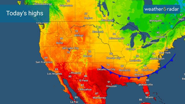
The TemperatureRadar shows highs will only be in the 50s along the I-95 corridor from Washington northward to Boston, with Chicago and Detroit struggling to hit the upper 40s. These will be 15 to 20 degrees colder than normal values today.

The WeatherRadar shows a few showers will develop throughout the afternoon in the cold air as a bit of upper-level energy rotates around the low now in Canada. Not a washout, but these showers will definitely add a bit of chill to the day.

In stark contrast, Texas, the Gulf Coast and Florida will remain hot with afternoon highs in the low 90s possible. Similar readings are likely across the Southwest.

For the rest of the West Coast and Rockies, it will be a mostly pleasant and mild day. The Northwest could see some late-arriving showers in Seattle.

The TemperatureRadar shows a sharp temperature gradient across the eastern U.S.

Tropical update:

In the tropics, a tropical disturbance in the central Atlantic is being watched for additional development. It could develop into a depression as it approaches the Greater Antilles later this week.

Along the western Caribbean coastline, a low-pressure area will develop and could move towards Central America. This will be a major rainmaker for them.

News we are covering today:

  • Cold weather returns

Did you miss these?

Did you see it Monday morning?read more
Once in a lifetime comet viewread more
Auroras dazzle the night skyread more

App news & updates:

It's never too early to prepare for the winter season! Is your blizzard kit in order?

James West

More on the topic

10 facts about fog. Low clouds. . . Sunday, September 27, 2026
Fog impacting the Appalachian Mountains.
Sunday, September 27, 2026

Low clouds

10 facts about fog
What are weather fronts?. Weather explained. . . Saturday, October 24, 2026
Image of a temperature radar showing a clear distinction between a warm and cold air mass separated by a cold front.
Saturday, October 24, 2026

Weather explained

What are weather fronts?
How does fog form?. Multiple ways. . . Saturday, September 12, 2026
Saturday, September 12, 2026

Multiple ways

How does fog form?
All weather news

This might also interest you

Growing season slowly concludes. 1st frost not everywhere. . . Monday, October 26, 2026
Monday, October 26, 2026

1st frost not everywhere

Growing season slowly concludes
Useful tips when driving in the rain. Flood safety. . . Wednesday, October 28, 2026
Wednesday, October 28, 2026

Flood safety

Useful tips when driving in the rain
Autumn, Summer on one map. WeatherFeed. . . Tuesday, October 27, 2026
Today's top stories
Tuesday, October 27, 2026

WeatherFeed

Autumn, Summer on one map
All articles
Weather & Radar

Weather & Radar is also available on

Google Play StoreApp Store

Company

Contact us Privacy policy Legal info Accessibility statement

Services

Uploader

Socials

instagramfacebookthreadslinkList