Home / Discover the app /

Breakfast Brief: East U.S. storms, Plains heat

Breakfast Brief
East U.S. storms, Plains heat

Showers and thunderstorms are forecast across a large portion of the eastern U.S., while the western half of the country remains dry and exceptionally hot in some areas.

The work week starts with general showers and thunderstorms from the Midwest to Florida. The culprit is a low-pressure system that will gradually shift east across the eastern half of the country throughout the week. Expect the focus area of showers and thunderstorms to shift east following this storm as the week progresses.

Did you know?

On this day in 2021, overnight severe thunderstorms produced significant wind damage across the Chicago metro area. These storms brought strong winds that led to widespread property damage, downed trees, and power outages, impacting many residents and causing disruption in the region​.

The image shows dominant weather patterns across the Contiguous U.S. for Monday, July 29, 2024.

East of the Mississippi River, the main story will be about above-average temperatures and wildfires that continue to pump smoke into the atmosphere. The Central Plains will see the highest above average temperature on Monday with temperatures about 10 to 15 degrees above average.

Meanwhile, nearly 100 wildfires are burning across the U.S. West Coast and southwest Canada, with the most severe fires in Oregon and Washington. The fires are causing extensive smoke and haze, worsening air quality in the region.

Tropical update:

The tropics remain relatively calm except for the western Pacific, where an area of low pressure may continue to organize into a tropical cyclone over the next couple of days. However, impacts to the U.S. are not expected. Deep Saharan dust is taking over the Caribbean, limiting storm formation, but this dust will erode, and the weather pattern might turn more favorable for development next week. We are monitoring a tropical wave, still very far from the continental U.S.

The news we're covering today:

  • Downpours and gusty winds affecting New England
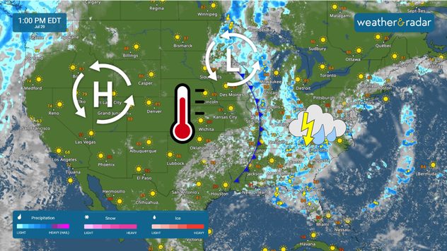
  • Showers and thunderstorms across the eastern half of the country
  • Smoke from the fires affects air quality and fires threaten property
  • Tropical wave moving toward the Caribbean

Did you miss these?

Coastal storm to slam New Englandread more
Flash flooding in TennesseeContinue reading
Heavy rain may relieve Carolina droughtread more

App news & updates

We've made a few changes to the Weather & Radar app on Android. When you delete your old home location, your current location becomes your new home location. This update is available with version 2024.15.1.

Download the app now
More app features
Split image showing a Weather & Radar USA infogrpahic on one side and icey street lights on the other due to freezing rain.

Snow, sleet or ice

How atmospheric temps shape winter precipitation
The image shows the preview of the Nowcast 90-minute weather feature on the Weather & Radar USA app.

Weather & Radar features

Precision forecast for better planning
Image shows and example of the WindRadar over Chicago, Illinois showing winds up to 30 mph across the city.

App feature

Learn about the WindRadar
All app features
Weather & Radar

www.weatherandradar.com

instagramfacebookthreadsContact uslinkList
Privacy policy | Legal info