Home / Editor's Pick /

Breakfast Brief: More tropical trouble, East heats up

09:00 AM
June 14, 2024

Breakfast brief
More tropical trouble, East heats up

Florida continues to experience heavy rains and flooding, while thunderstorm focus shifts towards the Northeast and Central Plains.

Did you know?

On this day in 1903, a significant flood event occurred in Heppner, Oregon. Known as the Heppner Flood, it was one of the deadliest flash floods in U.S. history. Heavy rains caused Willow Creek to overflow and sent a 40-foot wall of water rushing through the town. The devastating flood claimed the lives of approximately 247 people.

Today's weather outlook

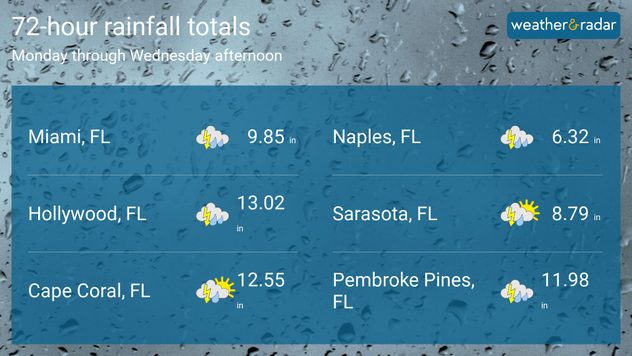
While Wednesday brought a brief respite from the heavy rains, Florida, particularly the southern regions, is bracing for more wet conditions through at least Saturday. With already saturated soils, it won't take much to spark flash flooding. As of Wednesday afternoon, 48-hour rainfall totals indicated that many locales across Florida, including Miami, Hollywood, Port Everglades, and Fort Lauderdale, hit daily rainfall records.

rainfall totals june 14

Rain and storms won't be confined to the Sunshine State. Today, an eastward-moving cold front will sweep across the Northeast, triggering showers and thunderstorms. The focus of strong to severe thunderstorms will be along a line from northern Virginia to southern New Hampshire, just west of the major I-95 metro areas.

A second area of concern for strong to severe storms today will be across the Central Plains, including parts of eastern Colorado, southwest Wyoming, and western Kansas. The primary threat from these storms will be large hail and wind gusts of up to 80 mph, beginning in the mid-afternoon.

Tropical update

A tropical system coined Invest-90 was pushed into the western Atlantic, with a low chance of developing into a tropical cyclone over the next 7 days. Meanwhile, a broad area of low pressure is forecast to form over the southwestern Gulf of Mexico this weekend or early next week. A tropical depression could form during the early or middle part of next week, bringing heavy tropical downpours to portions of eastern Mexico.

The news we're covering today:

  • May 2024 was Earth’s warmest May on record - Published in the evening
  • Flash flood threat ends in Florida?
  • Season's first long-duration heat wave expands to the Northeast

Did you miss these?

Flash floods cause chaos in Floridaread more
2024 Hurricane Season forecast updateread more
Preparing for 2024 hurricane seasonread more

App news & updates:

Now that we're in the longest days of the year, we know you have plenty of outdoor activities planned. We're here to support that! We've added length-of-day information to the Astro info card on all iOS devices. And don't worry Android users, this feature is coming to you soon, too.

Federico Di Catarina
More on the topic
Weather radar with dust plumes and webcam view of Mallorca with milky skies.
Saturday, August 30, 2025

Sky coloured orange

Saharan dust over Spain
On the left, a satellite image of a hurricane over the sea; on the right, a man in a clearance vehicle clearing debris and food in a flooded supermarket.
Friday, August 29, 2025

Twenty years ago today

Hurricane Katrina hit Gulf Coast
Dust cloud over Tucson alongside weather radar showing thunderstorms in Arizona.
Sunday, August 31, 2025

Fascinating phenomenon

Dust storm hit Phoenix last week
All weather news
This might also interest you
Thursday, September 11, 2025

High tides

Coastal flooding continues
Wednesday, September 10, 2025

Daily briefing

Quiet week continues
Tuesday, September 9, 2025

Daily briefing

Autumn quiet locked in
All articles
Weather & Radar

www.weatherandradar.com

instagramfacebookthreadsContact uslinkList
Privacy policy | Legal info | Accessibility statement