Home
Weather New York
WeatherRadar
RainRadar
TemperatureRadar
WindRadar
LightningRadar
Weather News
Editor's Pick
Discover the app
Weather widget
Contact us
Apps
Career
    Home / Weather News /

    Colorado avalanche on camera

02:33 PM
February 24, 2025

Next Pacific storm
Colorado avalanche on camera

A security camera caught the moment an avalanche moved by a home in Evergreen, Colo. Our next Pacific storm will bring the risk of avalanches to communities in Idaho and Montana.

Warm temperatures and rain often trigger Avalanches by creating "weak" snow. The avalanche risk will increase in northern Idaho and western Montana through Tuesday as our next Pacific storm moves through.

What conditions trigger avalanchesread more

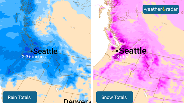
The WeatherRadar shows a Pacific storm bringing heavy rain, snow and gusty winds to the Northwest east into the northern Great Basin and Rockies through Tuesday.

Rain and snow totals over the next 48 hours.

A flood threat is in play along the Washington and Oregon coasts, including cities like Portland, Ore., and Olympia, Wash., with 1-3 inches of rain forecasted through Tuesday. Snow levels will stay high, but the highest elevations will pick up 1-3 feet of additional accumulation in the Cascades and northern Rockies.

Gusty winds will also be a concern across the Northwest. The WindRadar shows gusts up to 60 mph through Monday evening.

Mary Mays
More on the topic
Waterspouts possible, what are they?. They can be dangerous. . . Saturday, July 11, 2026
Waterspouts weatherradar.
Saturday, July 11, 2026

They can be dangerous

Waterspouts possible, what are they?
Super Typhoon Bavi threatens Taiwan. 155 mph winds. . Weather Videos. Wednesday, July 8, 2026
The image shows an intense tropical cyclone over the western Pacific, east of Taiwan and the Philippines. The centre of the system is depicted as a light purple and white vortex with a clearly visible eye, surrounded by a ring of red and orange areas indicating the strongest wind speeds. A white arrow marks the typhoon’s predicted track towards the north-west, in the direction of Taiwan. To the west of the storm lie the Philippines, with the cities of Manila and Cebu; to the north of these lies Taiwan, with Taipei. Further west, the Chinese coast, including Hong Kong, and parts of Vietnam can be seen. The coloured wind map shows predominantly green areas outside the storm’s core, indicating significantly weaker winds. White streamlines illustrate the typhoon’s anti-clockwise circulation in the Northern Hemisphere. The highest wind speeds are concentrated around the eye of the cyclone.
Weather VideosWednesday, July 8, 2026

155 mph winds

Super Typhoon Bavi threatens Taiwan
Record-breaking heatwave in Europe. Hotter than most of U.S.. . . Thursday, June 25, 2026
Thursday, June 25, 2026

Hotter than most of U.S.

Record-breaking heatwave in Europe
All weather news
This might also interest you
When severe storms strike.... You can be ready. . . Saturday, July 18, 2026
Saturday, July 18, 2026

You can be ready

When severe storms strike...
Area to watch this weekend. Tropical trouble?. . . Wednesday, July 15, 2026
An area of low pressure is expected to develop this weekend off Florida's Big Bend. The question is: will this mean tropical trouble for the Southeast?
Wednesday, July 15, 2026

Tropical trouble?

Area to watch this weekend
SW Texas quadruples its normal July rain. 7 inches and counting. . . Tuesday, July 14, 2026
Tuesday, July 14, 2026

7 inches and counting

SW Texas quadruples its normal July rain
All articles
Weather & Radar

Weather & Radar is also available on

Google Play StoreApp Store

Company

Contact us Privacy policy Legal info Accessibility statement

Services

Uploader

Socials

instagramfacebookthreadslinkList