Home
Weather New York
WeatherRadar
RainRadar
TemperatureRadar
WindRadar
LightningRadar
Weather News
Editor's Pick
Discover the app
Weather widget
Contact us
Apps
Career
    Home / Weather News /

    Daily briefing: More Autumnal signs

09:00 AM
September 2, 2025

Daily briefing
More Autumnal signs

It is going to be a quiet Tuesday across most of the U.S., as summer vacation has officially ended with yesterday's Labor Day holiday. These details, along with our daily tropical outlook, are published every weekday at 5 a.m. ET.

The hot spot for weather will be across the Southern tier. A stubborn stationary front will produce a few afternoon thunderstorms across Florida, along the Gulf Coast and across southern and eastern Texas. These will not be total washouts.

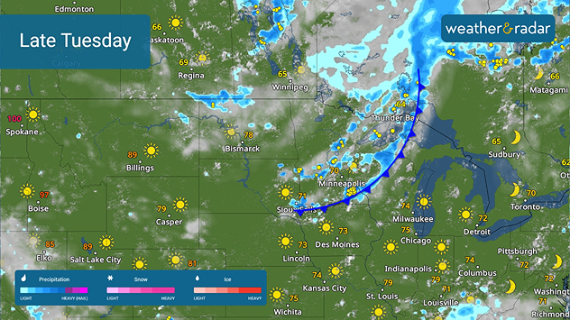
A cold front will move across the Upper Midwest later today

Signs of autumn will encroach the northern Plains and the Upper Midwest. A cold front sliding south out of Canada later today will produce some rain and dropping temperatures by sunset. Take a peek at the TemperatureRadar on Wednesday to see how much colder the week will be.

The rest of the U.S. will be mostly sunny and quiet today. Afternoon highs will be in the 70s and 80s in most places, with 90s found across the West and triple-digits in the Southwest.

Tropical Update

A tropical wave zipping across the far eastern Atlantic may see some development in the coming days. We'll keep a close eye on the Atlantic Basin.

App News

The Atlantic Hurricane Season peaks in September, and you will want to be ready. Learn more about how our hurricane alerts work here.

James West
More on the topic
Hurricane parade in the Pacific. Karina is very strong. . Weather Videos. Tuesday, September 1, 2026
WindRadar for Friday, showing the three hurricanes – Lowell, Karina and Maria – over the Pacific.
Weather VideosTuesday, September 1, 2026

Karina is very strong

Hurricane parade in the Pacific
Hurricane Polo remains dangerous. Active Pacific. . . Thursday, September 24, 2026
Thursday, September 24, 2026

Active Pacific

Hurricane Polo remains dangerous
Record ocean heat halting hurricanes. Strong El Niño influence. . . Sunday, September 13, 2026
A weather map shows a calm Atlantic Ocean with no hurricanes, alongside a picture of the sea.
Sunday, September 13, 2026

Strong El Niño influence

Record ocean heat halting hurricanes
All weather news
This might also interest you
45-degree temperature spread. Summer, fall on one map. . . Monday, October 12, 2026
Monday, October 12, 2026

Summer, fall on one map

45-degree temperature spread
Soggy end to the weekend for some. Remnants of Isaias. . . Sunday, October 11, 2026
While Isaias may have made landfall near Destin, Fla., Friday night, the hurricane's remnants will bring a soggy end to the weekend hundreds of miles away from the point of landfall.
Sunday, October 11, 2026

Remnants of Isaias

Soggy end to the weekend for some
Tropical downpours for the West. Rachel's remnants. . . Sunday, October 11, 2026
Not just one, but two post-tropical systems are bringing a deluge to the U.S. this weekend. Moisture from the remnants of Tropical Storm Rachel will bring downpours to parts of the West into early next week.
Sunday, October 11, 2026

Rachel's remnants

Tropical downpours for the West
All articles
Weather & Radar

Weather & Radar is also available on

Google Play StoreApp Store

Company

Contact us Privacy policy Legal info Accessibility statement

Services

Uploader

Socials

instagramfacebookthreadslinkList