Home
Weather New York
WeatherRadar
RainRadar
TemperatureRadar
WindRadar
LightningRadar
Weather News
Editor's Pick
Discover the app
Weather widget
Contact us
Apps
Career
    Home / Weather News /

    Daily briefing: Record heat, powerful west coast storm

10:00 AM
November 14, 2025

Daily briefing
Record heat, powerful west coast storm

A strong storm system will impact the West today, while lake-effect snow continues for the eastern Great Lakes. This, along with our tropical update, is available at 5 a.m. ET in our daily briefing.

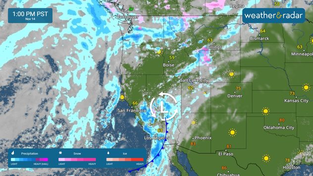
The WeatherRadar shows our Pacific storm continuing to bring heavy rain, gusty winds and mountain snow to the West Coast. Rain and mountain snow will also extend into the Great Basin and the northern Rockies today.

The WeatherRadar shows a Pacific Storm impacting the West Coast today.

Some flash flooding will be possible, especially in burn-scar areas, as an additional 3-4 inches of rain falls across parts of central and southern California. Flash flooding will be possible in cities like Los Angeles, Santa Barbara and Fresno, Calif. Travel along mountain passes will continue to be an issue as heavy snow continues in parts of the Sierra.

The rest of the country will be dry, with the exception of the Northeast, where scattered showers and high-elevation snow continue.

Temperatures will vary widely across the country. The western two-thirds of the U.S. will enjoy mild weather. The Northeast stays chilly today, with highs in the 30s and 40s. Southern California, the central Plains, and the Southeast will see highs into the 60s and 70s, while the Desert Southwest and southern Plains will see highs in the 80s. Record highs will be possible today in cities like Rapid City, S.D., Lincoln, Neb., Tulsa, Okla. and Amarillo, Texas.

Tropical Update

Tropical activity is not expected over the next several days. We continue to monitor the tropics as the Atlantic Hurricane Season lasts until November 30.

App News

Getting to know your way around the Weather & Radar app just became very easy! Browse our 'Discover the App' section to learn more about the features we offer to help you make your daily weather decisions.

Mary Mays
More on the topic
The best views of Wednesday's eclipse. Europe's sky show. . . Thursday, August 13, 2026
Solar eclipse: The sun obscured between wind turbines in Sardinia
Thursday, August 13, 2026

Europe's sky show

The best views of Wednesday's eclipse
All about nocturnal severe weather. Risks & preparedness. . . Saturday, August 22, 2026
Saturday, August 22, 2026

Risks & preparedness

All about nocturnal severe weather
Super Typhoon Bavi threatens Taiwan. 155 mph winds. . Weather Videos. Wednesday, July 8, 2026
The image shows an intense tropical cyclone over the western Pacific, east of Taiwan and the Philippines. The centre of the system is depicted as a light purple and white vortex with a clearly visible eye, surrounded by a ring of red and orange areas indicating the strongest wind speeds. A white arrow marks the typhoon’s predicted track towards the north-west, in the direction of Taiwan. To the west of the storm lie the Philippines, with the cities of Manila and Cebu; to the north of these lies Taiwan, with Taipei. Further west, the Chinese coast, including Hong Kong, and parts of Vietnam can be seen. The coloured wind map shows predominantly green areas outside the storm’s core, indicating significantly weaker winds. White streamlines illustrate the typhoon’s anti-clockwise circulation in the Northern Hemisphere. The highest wind speeds are concentrated around the eye of the cyclone.
Weather VideosWednesday, July 8, 2026

155 mph winds

Super Typhoon Bavi threatens Taiwan
All weather news
This might also interest you
6 riskiest places to live: hurricane edition. Do you live there?. . . Sunday, August 16, 2026
Hurricane Irma covers the entiret of Florida with Hurricane Maria coming up behind it.
Sunday, August 16, 2026

Do you live there?

6 riskiest places to live: hurricane edition
The South sweats for a while. 14-Day trend. . . Wednesday, August 19, 2026
Wednesday, August 19, 2026

14-Day trend

The South sweats for a while
20 days of at least 100°F. Southern Plains. . . Thursday, August 20, 2026
Thursday, August 20, 2026

Southern Plains

20 days of at least 100°F
All articles
Weather & Radar

Weather & Radar is also available on

Google Play StoreApp Store

Company

Contact us Privacy policy Legal info Accessibility statement

Services

Uploader

Socials

instagramfacebookthreadslinkList