Home
Weather New York
WeatherRadar
RainRadar
TemperatureRadar
WindRadar
LightningRadar
Weather News
Editor's Pick
Discover the app
Weather widget
Contact us
Apps
Career
    Home / Weather News /

    Daily briefing: Snowy Thanksgiving for the Great Lakes

10:00 AM
November 27, 2025

Daily briefing
Snowy Thanksgiving for the Great Lakes

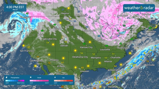
Lake-effect snow pounds the Great Lakes today, with another Pacific storm bringing rain and mountain snow to the Northwest. This, along with our tropical update, is available at 5 a.m. ET in our daily briefing.

A potent lake-effect snow event will bring quite a bit of snow to the Great Lakes today. It will be a white Thanksgiving in cities like Marquette and Cadillac, Mich., Cleveland, Erie, Pa., and Watertown, N.Y. The snow belts will see up to a foot or more of snowfall.

The WeatherRadar shows lake-effect snow for the Great Lakes and another storm moving into the Pacific Northwest.

The Pacific Northwest will see rain and mountain snow as another system moves in from the Pacific. It will be a soggy Turkey Day in Portland, Ore., and Seattle. With snow showers impacting the higher elevations in the northern Cascades.

In addition to snow, gusty winds are in play once again across the Great Lakes and into the Northeast. The WindRadar shows gusts of up to 40 mph in cities like Milwaukee, Wis., Detroit, Columbus, Ohio, and Albany, N.Y. These gusty winds can cause whiteout conditions in areas experiencing lake-effect snow.

It will be warm this afternoon along the West Coast, with 60s and 70s. Cities like Phoenix and Los Angeles will reach the mid-70s this afternoon. The deep South and Texas will see 60s, but temperatures stay near or below-freezing across the northern Plains, Upper Midwest and into the Great Lakes.

Tropical Update

Tropical activity is not expected over the next several days. We continue to monitor the tropics as the Atlantic Hurricane Season lasts until November 30.

App News

Getting to know your way around the Weather & Radar app just became very easy! Browse our 'Discover the App' section to learn more about the features we offer to help you make your daily weather decisions.

Mary Mays
More on the topic
Hurricane Polo remains dangerous. Active Pacific. . . Thursday, September 24, 2026
Thursday, September 24, 2026

Active Pacific

Hurricane Polo remains dangerous
Meteorological vs astronomical autumn. Season start date. . . Tuesday, September 1, 2026
Tuesday, September 1, 2026

Season start date

Meteorological vs astronomical autumn
Hurricane Polo heads for Mexico. Severe weather risk. . . Monday, September 28, 2026
Hurricane Polo is set to make landfall in the Baja-California.
Monday, September 28, 2026

Severe weather risk

Hurricane Polo heads for Mexico
All weather news
This might also interest you
Isaias landfall dangers. Surge, outages, flooding. . . Friday, October 9, 2026
Friday, October 9, 2026

Surge, outages, flooding

Isaias landfall dangers
Be ready for tropical activity. Tips & tools. . . Wednesday, October 7, 2026
Track hurricanes with the WeatherRadar
Wednesday, October 7, 2026

Tips & tools

Be ready for tropical activity
First hurricane of the Atlantic season. Isaias forms. . . Thursday, October 8, 2026
After a quiet start, the Atlantic's first hurricane has finally formed. Isaias is the latest first hurricane since the satellite era began in1966. With the Gulf Coast in sight, what impacts are expected?
Thursday, October 8, 2026

Isaias forms

First hurricane of the Atlantic season
All articles
Weather & Radar

Weather & Radar is also available on

Google Play StoreApp Store

Company

Contact us Privacy policy Legal info Accessibility statement

Services

Uploader

Socials

instagramfacebookthreadslinkList