Home
Weather New York
WeatherRadar
RainRadar
TemperatureRadar
WindRadar
LightningRadar
Weather News
Editor's Pick
Discover the app
Weather widget
Contact us
Apps
Career
    Home / Weather News /

    Major storm brings severe weather threat
10:00 AM
March 4, 2025

Breakfast Brief
Major storm brings severe weather threat
A powerful storm is set to move across the central U.S. today, bringing the risk of severe storms and winter weather. Make sure you stay weather-aware. The Breakfast Brief is published daily, Monday through Friday, at 5:00 a.m. Eastern time.

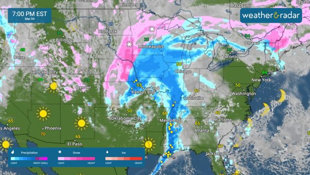
The WeatherRadar shows a powerful storm moving across the central part of the country, bringing multiple hazards, including severe storms, damaging high winds and the threats of flash flooding and blizzard conditions.

1/2

Our severe threat broadens today as low pressure drives a strong cold front rapidly eastward across the Lower Mississippi Valley, Mid-South and Gulf Coast region. An enhanced risk (level 3 of 5) of severe weather extends from the Arklatex down to the central Gulf Coast where there will be concerns for very strong damaging winds, tornadoes, and some large hail.

Severe storms may impact Mardi Gras festivities in New Orleans today. Other cities at risk for severe weather include Dallas, Little Rock, Ark., Shreveport, La., Memphis, Birmingham and Mobile, Ala. The most significant risk of strong tornadoes extends across northern and central Louisiana, southern Mississippi and southwest Alabama. A flash flood threat will also overlap many of the areas at risk of strong storms.

The cold side of this storm also brings the threat of blizzard conditions. After bringing 1 to 2 feet of snow to the Rockies, this same storm will spread a swath of heavy snow and very strong winds across the central High Plains to the upper Midwest. Snow totals will range from 2 to 8 inches, but gusty winds will lead to blizzard conditions across parts of eastern Colorado and Nebraska.

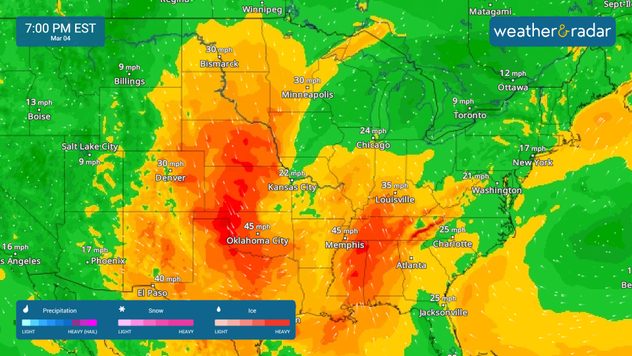
These same gusty winds will also lead to an extreme fire threat across New Mexico and Texas. The WindRadar shows gusts over 50 mph in cities like San Antonio and Austin, Texas.

News we're covering

  • Wildfires in the Carolinas
  • Severe storm threat across the South

Things you might have missed

Carolina wildfiresread more
March astronomy outlookread more

App news & updates:

Severe weather is likely this week. Make sure you have severe weather alerts turned on! Find out how here.

Mary Mays
More on the topic
Meteorological summer is here!. Bye, spring!. . . Monday, June 1, 2026
Monday, June 1, 2026

Bye, spring!

Meteorological summer is here!
Europe: Warmest June on record. Warm waters too. . . Friday, July 10, 2026
The record-breaking heatwave in June has made climate history in Western Europe.
Friday, July 10, 2026

Warm waters too

Europe: Warmest June on record
High pressure & extreme heat. Why & how does it work?. . . Sunday, July 12, 2026
Sunday, July 12, 2026

Why & how does it work?

High pressure & extreme heat
All weather news
This might also interest you
Lopsided Bertha moves west. Who sees the impacts. . . Thursday, July 23, 2026
Thursday, July 23, 2026

Who sees the impacts

Lopsided Bertha moves west
How does a hurricane form?. Hurricane preparedness. . . Sunday, July 19, 2026
hurricane maria
Sunday, July 19, 2026

Hurricane preparedness

How does a hurricane form?
Temps 15-degrees below average. Big cold front. . . Wednesday, July 22, 2026
Wednesday, July 22, 2026

Big cold front

Temps 15-degrees below average
All articles
Weather & Radar

Weather & Radar is also available on

Google Play StoreApp Store

Company

Contact us Privacy policy Legal info Accessibility statement

Services

Uploader

Socials

instagramfacebookthreadslinkList