Home
Weather New York
WeatherRadar
RainRadar
TemperatureRadar
WindRadar
LightningRadar
Weather News
Editor's Pick
Discover the app
Weather widget
Contact us
Apps
Career
    Home / Weather News /

    Rain melts Southern Ice

02:32 PM
February 3, 2026

Plus, warmer highs
Rain melts Southern Ice

Rain moves into the South today, helping to melt any lingering ice. A few snow showers stretch across the Ohio Valley and into the Mid-Atlantic.

We're monitoring a developing low on the WeatherRadar over the southern Plains. This system will track east across the South today and move through the Southeast on Wednesday.

Moisture from the Gulf will fuel showers and embedded thunderstorms across eastern Texas this morning. This activity will expand through the Arklatex this afternoon, spread across much of the South tonight and reach the Gulf Coast and Southeast on Wednesday. This wet weather will help melt the remaining ice from last week's devastating ice storm that slammed parts of the South.

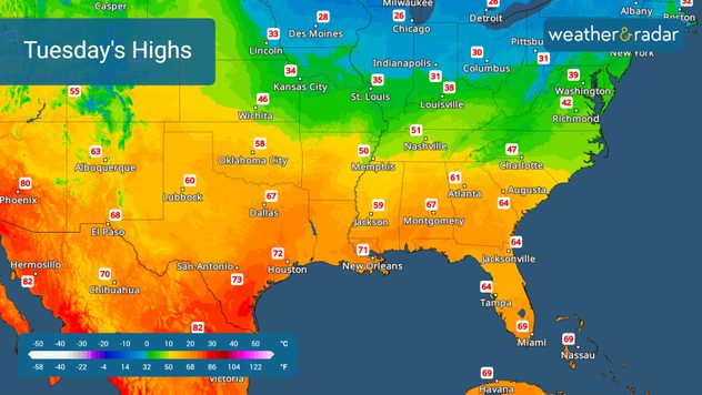
The Temperature-Radar shows above-freezing highs across the South.

The TemperatureRadar shows highs returning to more seasonable numbers across the South. Nashville, Tenn., will warm to the low 50s today, while Atlanta, New Orleans and Houston will reach the 60s and 70s.

Farther north, the TemperatureRadar shows a modest push of Arctic air into the Great Lakes, bringing wintry weather to the upper Ohio Valley later today. This wintry mix will spread across the central Appalachians into the Mid-Atlantic tonight into Wednesday morning before tapering off, while additional showers and storms move through the Southeast Wednesday night and into Florida by Thursday morning.

Mary Mays
More on the topic
Europe: Warmest June on record. Warm waters too. . . Friday, July 10, 2026
The record-breaking heatwave in June has made climate history in Western Europe.
Friday, July 10, 2026

Warm waters too

Europe: Warmest June on record
How does fog form?. Multiple ways. . . Saturday, July 11, 2026
Saturday, July 11, 2026

Multiple ways

How does fog form?
Super Typhoon Bavi threatens Taiwan. 155 mph winds. . Weather Videos. Wednesday, July 8, 2026
The image shows an intense tropical cyclone over the western Pacific, east of Taiwan and the Philippines. The centre of the system is depicted as a light purple and white vortex with a clearly visible eye, surrounded by a ring of red and orange areas indicating the strongest wind speeds. A white arrow marks the typhoon’s predicted track towards the north-west, in the direction of Taiwan. To the west of the storm lie the Philippines, with the cities of Manila and Cebu; to the north of these lies Taiwan, with Taipei. Further west, the Chinese coast, including Hong Kong, and parts of Vietnam can be seen. The coloured wind map shows predominantly green areas outside the storm’s core, indicating significantly weaker winds. White streamlines illustrate the typhoon’s anti-clockwise circulation in the Northern Hemisphere. The highest wind speeds are concentrated around the eye of the cyclone.
Weather VideosWednesday, July 8, 2026

155 mph winds

Super Typhoon Bavi threatens Taiwan
All weather news
This might also interest you
Low pressure brings wet weekend. Soggy East. . . Friday, July 31, 2026
Friday, July 31, 2026

Soggy East

Low pressure brings wet weekend
Three common misperceptions. Hurricane season. . . Sunday, August 2, 2026
Hurricane Ian (2022) satellite imagery before SWFL landfall.
Sunday, August 2, 2026

Hurricane season

Three common misperceptions
Southwest heat disrupts daily flow. Closures & delays. . . Monday, July 27, 2026
Monday, July 27, 2026

Closures & delays

Southwest heat disrupts daily flow
All articles
Weather & Radar

Weather & Radar is also available on

Google Play StoreApp Store

Company

Contact us Privacy policy Legal info Accessibility statement

Services

Uploader

Socials

instagramfacebookthreadslinkList