Home / Weather News /

Sierra Nevada storm recap: Winds to Category 4 Hurricane strength

01:00 AM
March 5, 2024

Sierra Nevada storm recap
Winds to Category 4 Hurricane strength

Recommended external content from YouTube

We need your consent to show content from YouTube. You can withdraw your consent at any time.

I agree that content from YouTube will be displayed to me.

Settings for external content

Privacy policy

One of the most impactful storms, especially in the Sierra Nevada and Great Basin, this year just wrapped up across the western U.S. More than 6 feet of snow, with locally higher amounts, piled up on top of what was already in the Sierra Nevada snowpack. Heavy rainfall was noted as well.

Snow & Winds

A well-forecast snowstorm and blizzard event in the Sierras and Great Basin has just wrapped up after bringing heavy snow and hurricane-force gusts for nearly four full days between Thursday, February 29, and March 3. Blizzard warnings were issued at least 48 hours in advance, giving residents and travelers a heads-up about the dangerous conditions in the mountains.

The northern Sierra was hit hard by snowfall and the blizzard conditions, especially. The highest snow reports are coming out of Sugar Bowl, just south of Interstate 80 and Donner Pass, with 126 inches or 10.5 feet! Soda Springs wasn't too far off with 9.6 feet or 116 inches.

Near Lake Tahoe in Palisades Tahoe Ski Base, winds gusted to 145 mph at 8,700 feet in elevation – Category 4 hurricane strength. Wind gusts of 138 mph and 114 mph were reported in Sagehen Creek Field Station and Mammoth Mountain, respectively.

Rainfall

Although this was not a memorable rainfall event, it still packed a punch over the 4-day span. Honeydew, Calif., reported more than 7 inches of rainfall, with half-foot readings being recorded in both northern California, Oregon, and Washington as the storm hit the coast.

The short-term impacts of the heavy rainfall can bring many issues such as flash flooding, mudslides, and landslides, but the long-term impacts will be seen in lesser drought and more water table availability.

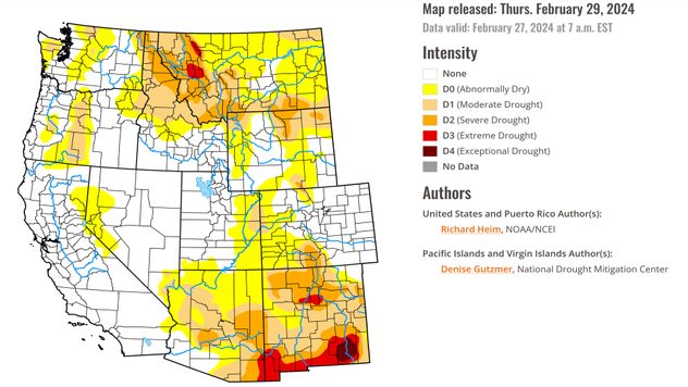
Currently, California is only experiencing abnormally dry conditions in a very small area – a great start as we head into the warmer seasons.

Latest drought update as of February 27, 2024.Latest drought update as of February 27, 2024. - © National Drought Mitigation Center University of Nebraska-Lincoln

The snowpack in the Sierras should be close if not above its normal water equivalent now that this large storm system has wrapped up. The last overall measurement was on March 1st when the storm was just getting started, so we look forward to seeing the latest update later this week.

However, the Snow Lab in the central Sierras is already reporting 98 percent of their median season peak!

Those who decided to make the trek into the mountains during the snowstorm found out quickly why staying home was best. Between trucking services and hopeful skiers, the main mountain passes were completely cut off or closed at many points in time due to the life-threatening conditions.

Becca Parker
More on the topic
Sleeping cat
Sunday, April 20, 2025

Seasonal tiredness

What causes spring fatigue?
Sunday, March 30, 2025

Your weather - Your shots

Spring tranquillity across the pond
Saturday, April 26, 2025

Off the coast of Sardinia

Waterspout seen from cruise ship
All weather news
This might also interest you
Friday, May 23, 2025

Breakfast Brief

Strong storms in the Plains
Thursday, May 22, 2025

2025 hurricane prediction

Above-average expected
Breakfast Brief with a highlight on the severe threat.
Tuesday, May 20, 2025

Breakfast Brief

Severe threat shifts to Deep South, Midwest
All articles
Weather & Radar

www.weatherandradar.com

instagramfacebookthreadsContact uslinkList
Privacy policy | Legal info