Home
Weather New York
WeatherRadar
RainRadar
TemperatureRadar
WindRadar
LightningRadar
Weather News
Editor's Pick
Discover the app
Weather widget
Contact us
Apps
Career
    Home / Editor's Pick /

    Spectacular video: Aurora in Norway

02:45 PM
October 18, 2022

Spectacular video
Aurora graces Norway

Privacy policy

A magical display of aurora was once again captured in Tromsø, Norway on October 15, 2022.

While the aurora, or northern lights in the northern hemisphere, doesn't move quite so fast in real life, this spectacular time-lapse showcases the beauty that earth had to offer us over the weekend.

In this video, a stunning array of greens, pinks, and purples can be seen, attributed to the gases present in the atmosphere. Green is the most common color to see and is associated with oxygen, whilst purple, blue, or pink are typical with nitrogen.

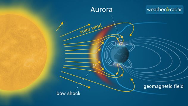
aurora infographic

Auroras are caused when the sun ejects significant amounts of particles toward Earth, during periods of heightened solar activity. This material then interacts with the Earth's magnetic fields and the gases in our atmosphere, producing the display.

While most common toward the arctic circle (in the latitudes of the Northern Hemisphere) from autumn to spring, they can also be visible on occasions in the US, normally across the northern half if anywhere though!

Weather & Radar USA editorial team
More on the topic
High pressure & extreme heat. Why & how does it work?. . . Sunday, July 12, 2026
Sunday, July 12, 2026

Why & how does it work?

High pressure & extreme heat
Super Typhoon Bavi threatens Taiwan. 155 mph winds. . Weather Videos. Wednesday, July 8, 2026
The image shows an intense tropical cyclone over the western Pacific, east of Taiwan and the Philippines. The centre of the system is depicted as a light purple and white vortex with a clearly visible eye, surrounded by a ring of red and orange areas indicating the strongest wind speeds. A white arrow marks the typhoon’s predicted track towards the north-west, in the direction of Taiwan. To the west of the storm lie the Philippines, with the cities of Manila and Cebu; to the north of these lies Taiwan, with Taipei. Further west, the Chinese coast, including Hong Kong, and parts of Vietnam can be seen. The coloured wind map shows predominantly green areas outside the storm’s core, indicating significantly weaker winds. White streamlines illustrate the typhoon’s anti-clockwise circulation in the Northern Hemisphere. The highest wind speeds are concentrated around the eye of the cyclone.
Weather VideosWednesday, July 8, 2026

155 mph winds

Super Typhoon Bavi threatens Taiwan
Meteorological summer is here!. Bye, spring!. . . Monday, June 1, 2026
Monday, June 1, 2026

Bye, spring!

Meteorological summer is here!
All weather news
This might also interest you
How does a hurricane form?. Hurricane preparedness. . . Sunday, July 19, 2026
hurricane maria
Sunday, July 19, 2026

Hurricane preparedness

How does a hurricane form?
Be prepared for wildfires. By using the app. . . Saturday, July 18, 2026
Wildfires can spark anywhere, anytime. The Weather & Radar app can help you determine your area's risk.
Saturday, July 18, 2026

By using the app

Be prepared for wildfires
Temps 15-degrees below average. Big cold front. . . Wednesday, July 22, 2026
Wednesday, July 22, 2026

Big cold front

Temps 15-degrees below average
All articles
Weather & Radar

Weather & Radar is also available on

Google Play StoreApp Store

Company

Contact us Privacy policy Legal info Accessibility statement

Services

Uploader

Socials

instagramfacebookthreadslinkList