Home
Weather New York
WeatherRadar
RainRadar
TemperatureRadar
WindRadar
LightningRadar
Weather News
Editor's Pick
Discover the app
Weather widget
Contact us
Apps
Career
    Home / Weather News /

    Strong storms firing up in the Midwest: Winds and large hail

03:03 PM
July 2, 2024

Winds and large hail
Strong storms firing up in the Midwest

Strong storms are firing up in the Central Plains and Midwest this afternoon and will continue this evening and into the overnight.

While it was a stormy start for many across the Midwest this morning, another round of showers and storms are in play this afternoon and evening as another disturbance moves in from the central Rockies. With warm and humid air in place, storms will fire up once again stretching from eastern Colorado into Iowa.

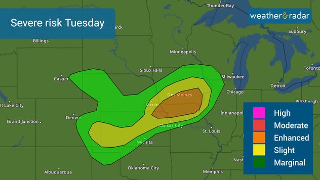
Tuesday's severe risk

Slight and enhanced risks, levels two and three out of five of severe storms, stretch from Iowa and northern Missouri southwestward through Kansas, southeastern Nebraska, eastern Colorado, and the Oklahoma Panhandle. The strongest storms will be across southern Iowa, northern Missouri, and northeastern Kansas. Des Moines, Iowa, Garden City, Kan., and Kansas City, should all be on alert for severe weather this afternoon, evening, and into the early morning hours of Wednesday.

Turn on your alertsread more

The storms that impact the central Plains and Midwest later today could bring damaging winds, large hail, and a few tornadoes. You will want to have the WeatherRadar up when storms start to approach. Also, don't forget to turn your Weather & Radar app alerts on before storms head your way.

More on the topic
Super Typhoon Near the Philippines. Gusts up to 155. . . Tuesday, June 23, 2026
Tuesday, June 23, 2026

Gusts up to 155

Super Typhoon Near the Philippines
Super Typhoon Bavi threatens Taiwan. 155 mph winds. . Weather Videos. Wednesday, July 8, 2026
The image shows an intense tropical cyclone over the western Pacific, east of Taiwan and the Philippines. The centre of the system is depicted as a light purple and white vortex with a clearly visible eye, surrounded by a ring of red and orange areas indicating the strongest wind speeds. A white arrow marks the typhoon’s predicted track towards the north-west, in the direction of Taiwan. To the west of the storm lie the Philippines, with the cities of Manila and Cebu; to the north of these lies Taiwan, with Taipei. Further west, the Chinese coast, including Hong Kong, and parts of Vietnam can be seen. The coloured wind map shows predominantly green areas outside the storm’s core, indicating significantly weaker winds. White streamlines illustrate the typhoon’s anti-clockwise circulation in the Northern Hemisphere. The highest wind speeds are concentrated around the eye of the cyclone.
Weather VideosWednesday, July 8, 2026

155 mph winds

Super Typhoon Bavi threatens Taiwan
Longest day of the year is here. Summer solstice. . . Sunday, June 21, 2026
Sunday, June 21, 2026

Summer solstice

Longest day of the year is here
All weather news
This might also interest you
Multi-day rain event ends soon. Southeast U.S.. . . Friday, July 24, 2026
Friday, July 24, 2026

Southeast U.S.

Multi-day rain event ends soon
Multi-Day flood threat for Mid-Atlantic. Stalled front. . . Wednesday, July 22, 2026
Wednesday, July 22, 2026

Stalled front

Multi-Day flood threat for Mid-Atlantic
Temps 15-degrees below average. Big cold front. . . Wednesday, July 22, 2026
Wednesday, July 22, 2026

Big cold front

Temps 15-degrees below average
All articles
Weather & Radar

Weather & Radar is also available on

Google Play StoreApp Store

Company

Contact us Privacy policy Legal info Accessibility statement

Services

Uploader

Socials

instagramfacebookthreadslinkList