Home
Weather New York
WeatherRadar
RainRadar
TemperatureRadar
WindRadar
LightningRadar
Weather News
Editor's Pick
Discover the app
Weather widget
Contact us
Apps
Career
Home / Weather News /

Winter storm & severe weather risk

10:00 AM
March 3, 2025

Breakfast Brief
Winter storm & severe weather risk

This will be a hectic week for us here at Weather & Radar. Make sure you stay weather-aware; many will deal with winter conditions, and others will deal with severe weather-- from the same system. The Breakfast Brief is published daily, Monday through Friday, at 5:00 a.m. Eastern time.

The week starts busy across much of the Rockies as a winter storm crosses the area. This is the same system that affected the West Coast during the weekend and is now moving east. Between Monday morning and Tuesday morning, the mountains in Colorado can expect anywhere between 8 inches and 16 inches of snow. The winds will also have strong gusts exceeding 50 mph at times.

1/2
A winter storm will bring rain and snow to Denver, while western Colorado will deal with rounds of heavy snow most of the day.

The winds will continue strong across southern Nevada, southeastern California, and western Arizona. Parts of Phoenix saw blowing dust as some wind gusts exceeded 60 mph, obstructing visibility on the roads and making them dangerous.

The system bringing winter conditions across the Rockies will continue to push eastward. The frontal boundary of the system will produce the chance for severe weather, which includes isolated large hail, damaging winds, and a few tornadoes across parts of North Texas and central and eastern Oklahoma. The severe weather starts late Monday afternoon and lasts into Monday night.

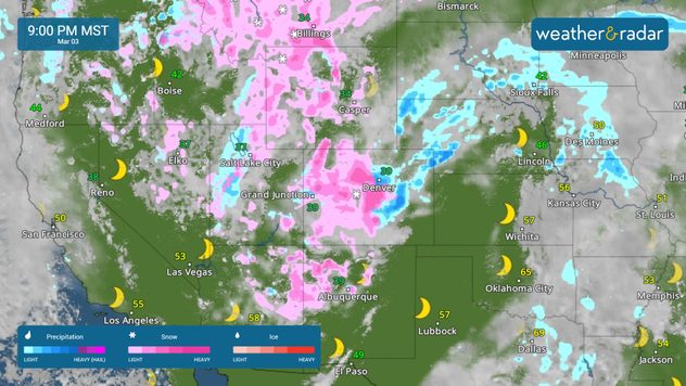
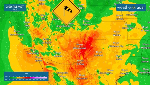
Heads-up! More dangerous weather for Tuesday!

This storm will continue to move east, and the chance for severe weather will continue to travel east with it. Parts of the Deep South will be seen and enhanced for severe weather to develop on Tuesday afternoon into the evening hours. About 3 1/2 million people are at risk of severe weather, specifically under an enhanced risk, over Louisiana, central and western Mississippi, and southeastern Arkansas.

Surrounding this enhanced risk, there’s still the chance for severe weather from eastern Texas all across eastern Oklahoma through much of Alabama. A few supercells could develop, producing damaging wind, gusts, a few tornadoes, and hail.

News we're covering

  • Wildfires in the Carolinas
  • Winter storm in the Rockies
  • Severe weather outlook for the South

Things you might have missed

March astronomy outlookread more
Japan's diamond jewelery iceread more

App news & updates:

Severe weather is likely this week. Make sure you have severe weather alerts turned on! Find out how here.

Irene Sans
More on the topic
pothole repair
Thursday, February 26, 2026

Bumpy commute

Cold = spring potholes
Weather radar with tornado symbol over Michigan next to photo of a destroyed building with collapsed roof and scattered debris.
Extreme WeatherSaturday, March 7, 2026

Deaths, extensive damage

Tornado in Michigan, severe outbreak continues
Foggy conditions in the roads. Drive safely, use low beams, high beams reflect more light, obstructing visibility more.
Friday, March 6, 2026

Safety tips: Fog

Driving during foggy conditions
All weather news
This might also interest you
Friday, March 13, 2026

Heavy snow, high winds

Winter returns to the Upper Midwest
Sunday, March 8, 2026

Flood safety

Useful tips when driving in the rain
Saturday, March 14, 2026

Incredible video

How do tornadoes form?
All articles
Weather & Radar

Weather & Radar is also available on

Google Play StoreApp Store

Company

Contact us Privacy policy Legal info Accessibility statement

Services

Uploader

Socials

instagramfacebookthreadslinkList