Home / Weather News /

Active west, snow for the Appalachians

10:00 AM
January 3, 2025

Breakfast brief
Active west, snow for the Appalachians

Much colder air will push southeast today while temperatures remain above average in the southwest. Low pressure will bring snow to parts of the Ohio Valley and the Appalachians, and active weather continues to impact the Pacific Northwest. The Breakfast Brief is published daily Monday through Friday at 5:00 a.m. Eastern time.

The WeatherRadar shows a quick-moving low pressure that will spread snow showers across the Ohio Valley and the central Appalachians. Anywhere from 1 to 3 inches of snow is expected across the Ohio Valley, with accumulations of 6 to 12 inches possible over the Central Appalachians.

On this day in weather history...

In 1961, a three day long ice storm was in progress over northern Idaho which produced an accumulation of ice eight inches thick, a U.S. record.

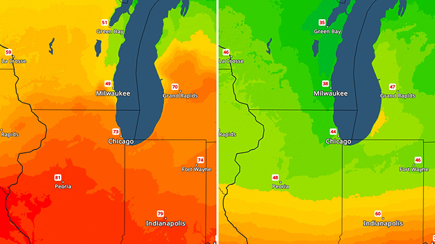
The wintry weather expected today across the Ohio Valley and the Appalachians wouldn't be possible without the arctic air surging south and east. The TemperatureRadar shows highs up to 25 degrees below average across the northern Plains and 10-15 degrees below average across the Midwest and Northeast. Single-digit highs are expected in cities like Bismarck, N.D., and Minneapolis.

Heavy coastal rain and mountain snow will proliferate across the Pacific Northwest as our active pattern continues. More than a foot of snow is possible in the highest elevations of the Cascades and Sierra, while 3-4 inches of rain are possible along the coast.

News we're covering today:

  • Big temperature drop for the eastern half
  • Big weekend storm
  • Active Pacific Northwest

Did you miss these?

Snow in western North Carolinaread more
First major winter storm of the seasonread more

Severe weather can strike at any time, even in winter. Check to make sure your app alerts are turned on.

Mary Mays
More on the topic
rip current
Monday, May 26, 2025

As more head to the coast

Rip currents & safety tips
Sunday, June 22, 2025

Why & how does it work?

High pressure & extreme heat
Saturday, May 3, 2025

May astronomy outlook

Meteor shower and the Flower Moon
All weather news
This might also interest you
Tuesday, July 1, 2025

Daily briefing

Storms roll into East
Saturday, June 28, 2025

Incredible video

How do tornadoes form?
Friday, July 4, 2025

Heavy rains, floods

Tropical Depression 3 forms near the Southeast
All articles
Weather & Radar

www.weatherandradar.com

instagramfacebookthreadsContact uslinkList
Privacy policy | Legal info | Accessibility statement