Home
Weather New York
WeatherRadar
RainRadar
TemperatureRadar
WindRadar
LightningRadar
Weather News
Editor's Pick
Discover the app
Weather widget
Contact us
Apps
Career
    Home / Editor's Pick /

    Severe storms in Texas, Rafael in the Gulf
10:00 AM
November 7, 2024

Breakfast Brief
Severe storms in Texas, Rafael in the Gulf

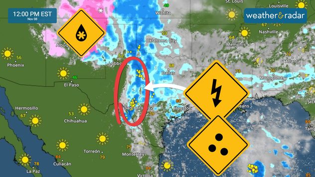
Rafael enters the Gulf of Mexico. A more westward turn is forecast, which means this hurricane will likely stay as a hurricane. Let's see what's happening today across the nation. For the latest Breakfast Brief please tap on the link here.

Let's start by highlighting the severe weather threat across parts of Texas. Isolated severe storms are possible, with some storms that could develop large hail and gusty winds. The severe storms are courtesy of the next storm system arriving from the west. This is the same system that produced snow showers across New Mexico. Snow will still be possible over New Mexico and southwestern Colorado on Thursday.

Today in history...

In 1957 a historic tornado outbreak impacted southeast Texas and southwestern Louisiana. Ten people were killed.

Santa Ana winds will continue to be strong over Southern California. Humidity will remain below 15%, and our WindRadar shows gusts could reach as high as 80 mph in some locations. These wind speeds could increase the fire risk and cause widespread power outages. Strong winds will persist through the rest of the week.

Tropical update:

Hurricane Rafael briefly became a major category 3 hurricane just before reaching western Cuba, with maximum sustained winds of at least 115 mph. The system entered the Gulf of Mexico and is now making a westward turn. This trajectory will keep Rafael over water and create a favorable environment for it to remain a hurricane, at least through late Friday. On late Saturday, the system will be moving through calmer waters, which will cut off the fuel to Rafael and weaken it drastically. Rafael will also possibly stay further away from the jet stream, which means that there is a chance that this system will stay over the Gulf of Mexico and stall. But it is more likely that it will be very weak if it does.

News we are covering today:

  • Hurricane Rafael to make a westward turn on Thursday
  • Wildfires in Southern California
  • Central Texas deals with isolated severe storms
  • First snow of the season in Santa Fe
  • Georgia flood threat

Did you miss these?

Dry vegetation, low humidity and windsread more
Last month of hurricane seasonread more

App news & updates:

Astronomical fall goes through December 21. but meteorological winter is around the corner. This is what it means.

Irene Sans
More on the topic
Super Typhoon Bavi threatens Taiwan. 155 mph winds. . Weather Videos. Wednesday, July 8, 2026
The image shows an intense tropical cyclone over the western Pacific, east of Taiwan and the Philippines. The centre of the system is depicted as a light purple and white vortex with a clearly visible eye, surrounded by a ring of red and orange areas indicating the strongest wind speeds. A white arrow marks the typhoon’s predicted track towards the north-west, in the direction of Taiwan. To the west of the storm lie the Philippines, with the cities of Manila and Cebu; to the north of these lies Taiwan, with Taipei. Further west, the Chinese coast, including Hong Kong, and parts of Vietnam can be seen. The coloured wind map shows predominantly green areas outside the storm’s core, indicating significantly weaker winds. White streamlines illustrate the typhoon’s anti-clockwise circulation in the Northern Hemisphere. The highest wind speeds are concentrated around the eye of the cyclone.
Weather VideosWednesday, July 8, 2026

155 mph winds

Super Typhoon Bavi threatens Taiwan
Waterspouts possible, what are they?. They can be dangerous. . . Saturday, July 11, 2026
Waterspouts weatherradar.
Saturday, July 11, 2026

They can be dangerous

Waterspouts possible, what are they?
Meteorological summer is here!. Bye, spring!. . . Monday, June 1, 2026
Monday, June 1, 2026

Bye, spring!

Meteorological summer is here!
All weather news
This might also interest you
Useful tips when driving in the rain. Flood safety. . . Saturday, August 1, 2026
Saturday, August 1, 2026

Flood safety

Useful tips when driving in the rain
Flooding rains shift north along I-95. 5 inches more. . . Wednesday, July 29, 2026
Extreme weather alerts are active as heavy rain could cause flooding issues.
Wednesday, July 29, 2026

5 inches more

Flooding rains shift north along I-95
Wildfire smoke on the WeatherRadar. Air quality concerns. . . Tuesday, August 4, 2026
Tuesday, August 4, 2026

Air quality concerns

Wildfire smoke on the WeatherRadar
All articles
Weather & Radar

Weather & Radar is also available on

Google Play StoreApp Store

Company

Contact us Privacy policy Legal info Accessibility statement

Services

Uploader

Socials

instagramfacebookthreadslinkList